2018/07 Arctic Part 1 - Beaver Lake |
|||||
Tuesday June 26th
The drizzle had turned to heavier rain, so we never took a look at the rest of the park. Our route took us to a bridge over the Peace River. The bridge gave us a good view of the Peace Canyon dam, a little way upstream, but it’s a narrow bridge with no walkways, so we didn’t risk waking out to take pictures. Further upstream is the massive Bennet Dam, which we toured with Bob back in 1986, when he and Pat lived in Chetwynd.
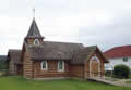 Nearby is the town of Hudson’s Hope, one of BC’s oldest towns, though a lot of the buildings date from the construction of the dams. An exception is this very pretty log church. On the Internet we see a lot about the town, usually accidentally because of “Hope” in the name. I was once stopped in Hope and asked where a street was. I said I hadn’t heard of it. He passed me a picture of a house and an address. I said “That’s in Hudson’s Hope”. “How far’s that?” “About two day’s drive.” “Oh! I s’pose that’s why it’s cheap.”
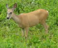
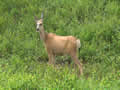
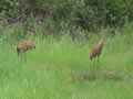
We were driving down the Peace River valley, truly peaceful and quiet. There are farms scattered through the valley, and the road cuts looked to be full of coal, but presumably not good enough for mining. This mule deer came so close we thought it had come over to chat with us.
| Mule deer (0.31) |
 |
|---|
This peace on the Peace is about to be destroyed by the construction of yet another dam. When I first heard about the plan on the radio I thought the dam had been given some Indian name like “T’seitsee”, so I was disappointed when I read it as “Site C”. A and B are the two dams already in place. One of the arguments against building it was the loss of agricultural land, but the farms only seemed to be growing hay for animals, and not very productive. Certainly though, there’ll be a loss of beauty.
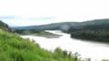 We stopped to look down on the valley, soon to be drowned. Behind us was a gaggle of construction vehicles, probably working on the road, which will need to be rerouted out of the valley. The road eventually swung away from the river so we couldn’t see the dam’s construction site, but there were many reminders installed by protesters “Water comes up to here.”
The rain seemed to be set in for the day. We joined the Alaska Highway at Charlie Lake, about mile 50. We’d be following it for about 800 miles, to Whitehorse in the Yukon, and then heading due north.
![]()
At this end of the highway it isn’t too exciting; two lanes, with a very wide cut through the forest. The good news is that large animals like deer and moose and bear are easier to spot before they get to the road.
There are few actual towns on the highway. Most places are no more than roadhouses with fuel, tyres, food, camping, and perhaps a motel. Originally, many of them just used their mile number as a name but the post office objected to numeric names. Guess where Wonowon is located.
Once again we passed the famous Pink Mountain without seeing the pink or even the mountain.
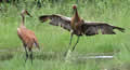 Just before we reached Fort Nelson the weather cleared a little and Sandie spotted these sandhill cranes.
 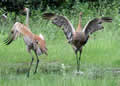 Luckily the Alaska Highway is the kind of road where you can usually reverse up the road while pointing a camera out the window. Cranes are quite common up north but it’s unusual to see them dancing.
| Sandhill cranes (0.39) |
 |
|---|
By the time we reached Fort Nelson the weather had changed again and an enormous storm looked to be hovering over the city. We just had time to fill up with diesel before the downpour began and we limped out of the city with the wipers on max.
Our campsite at Beaver Lake was just outside the storm a short way up the Liard Highway, a road we’d last taken on our 2013 trip to the Yellowknife area. The Liard was one of the quietest roads we’d ever traveled, just three cars in two days of driving.
The campground was quiet too; even the beaver was away. I wandered the only trail, still in the drizzle; carpets of bunchberries and a few wild roses and lots of mosquitoes enjoying the damp.