2018/07 Arctic Part 1 - Muncho Lake |
|||||
Wednesday June 27th
The good news was that we had a few patches of blue sky as we headed back south to rejoin the Alaska Highway. There was noticeably less traffic; we still saw RVs and campers like ours and long-distance trucks but we’d left the pickups and delivery trucks behind in Fort Nelson.
The scenery was more interesting as we began our climb into the Northern Rockies; rushing rivers, blue-green lakes, and 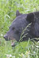 snowcapped mountains. We came across this black bear at the roadside, chomping away on the grass. Spring is a tough time for bears; winter-killed meat is long gone and it’s too early for berries and salmon, so they all have to spend a month or so eating salad.
| Eating bear (1.30) |
 |
|---|
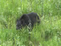
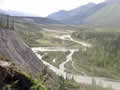
 Shortly afterwards we stopped at a rest area to look at this view of peaks and valleys. These were serious mountains, the Northern Rockies. We were chatting with other campers, most of them on their way to Alaska. Across the road was another bear, also eating grass. Nobody paid much attention to the bear; these were experienced travelers, treating bears as part of the scenery..
We stopped at the Tetsa River for coffee and for Sandie to look for good rocks in the riverbed, but the river was running high and 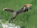 overflowing its banks.
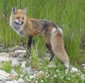
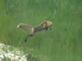
We came across a fox hunting amongst the roadside grass. It kept a careful eye on us but continued hunting, making high leaps and coming down on its prey. I’ve seen them do this for mice, but we think this one was doing it for bugs, probably grasshoppers.
| Hunting fox (3.21) |
 |
|---|
 We stopped at Summit Pass to look at its light blue lake and the flowers. The pass is at over 4000 feet and the section of road we’d driven that day was one of the most difficult sections of the Alaska Highway to build. We were at the beginning of Stone Mountain park, an alpine wonderland of peaks, geological folds, and waterfalls, but also some difficult driving. The road camber seems to be a few degrees off and bends in the road tighten at the worst moment. And this was in perfect driving weather. When I’d driven this section back in 2004 we’d had wet fog and I’d commented in the journal that it was a really scary drive.
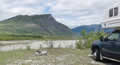
We followed a track out to the shore of the Racing River, which was living up to its name, racing just below us. Our coffee stop perch wasn’t much more than a pile of river rock that looked like it could slide into the river at any moment, so turning around to get out was a little tense.
The Toad River was also high. The story is that in the early days of the highway there was no bridge; instead, vehicles were winched or towed across the river. Over the years “Towed River” became “Toad River”. We stopped at the lodge there for fuel. After pressing the clear button, I went through the usual credit card PIN sequence and the instructions said to press the START button. Only I couldn’t find one. Sandie fetched the attendant who looked like she’d never seen the pump before, but hit the clear button again and the pump worked. She looked at us as if we were idiots and went back to the lodge. I can report to John and Edna that the ceiling inside t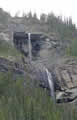 he lodge is still covered with hats – and once again I forgot to ask why.
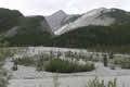
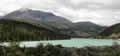
The scenery was changing again as we approached Muncho Lake: waterfalls, folded mountains, great alluvial fans,and, of course, the lake itself with its strange coppery green colour.
Much to our surprise we found a vacant slot along the lake shore. The view from our campsite was spectacular and ![]() constantly changing.
constantly changing.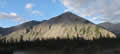
The light on the mountains around us was changing too as the sun went down
Sandie went looking for the pay station and she found that the woodlands were home to hundreds of yellow and ![]() white slipper orchids and other wildflowers.
white slipper orchids and other wildflowers.
 Thursday June 28th
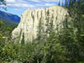
The sun was up long before we were, something else we’d have to get used to. We wanted to explore some of the park’s special places, but there wasn’t much signage to help. I remembered that there was a trail out to some pinnacles, but I wouldn’t have found it at all without that memory. It was actually a trail to an overlook above a salt lick, a place where animals come to lick minerals. There were none there but the view was great and we found
 the pinnacles too.
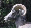
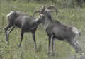
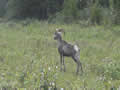
Back on the road we found a pair of stone sheep; maybe on their way to the lick.
| Sheep (1.30) |
 |
|---|
We drove down a track at Trout River but found it blocked to traffic. Sandie went to look at flowers and I walked the track to take a closer view of the river. I soon gave up as the river was actually flowing through the forest. On my way back I saw some motion in the undergrowth and went for a closer look. An animal came barreling out, straight at me. At the last minute it swerved and missed me and dove back into the undergrowth. It was a largish bird, hunched down so it looked like an attacking terrier. At first I thought it was a grouse, but they don’t attack like that. 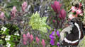 Then I realized it was a ptarmigan; back in ’89 I’d experienced similar attacks on Gros Morne mountain. I looked around and sure enough there were a couple of balls of fluff; ptarmigan chicks, hidden away in the undergrowth.
There were plenty of flowers; a few captured here in a composite.