2018/07 Arctic Part 1 - Moberley Lake |
|||||
Back on the highway, we had some letters to mail and Quesnel looked to be a good choice, big enough for a post office. Unfortunately, the road that the post office was on turned out to be under reconstruction. The whole road and its intersections had been dug out to about 4 feet down and was now a battle zone with bulldozers and back hoes. Men wearing hard hats were available to help peds like me get from A to B, but all the routes involved ankle deep mud. Sandals were a poor choice.
The next big place was Prince George and there we had to make a choice. We prefer the Cassiar Highway as a route north to the Yukon, but we’d be too early for the arrival of the salmon and all that their arrival triggers, so we opted for the more direct route up the Alaska Highway. We’d save the Cassiar for our way home.
We found a Canadian Tire to buy a few things for the trip, including a new axe, and then headed into a park for lunch. Unfortunately the park has a tiny and very steep parking lot and lots of foot trails, so we moved on and found ourselves in a very up-market housing estate. The only decent parking spot was in the middle of their turn-around so that’s where we had lunch, expecting to get a visit from the sheriff at any moment.
The scenery as we headed north was interesting: hills and lakes and various shades of green. It all looked to be perfect moose habitat, so I shouldn’t have been surprised when one burst out of the forest and headed for the road. All I could do was hit the brakes hard and hope that the traffic behind me could stop. The cow moose’s expression went from blissful ignorance to confusion to a desire to be somewhere else, and she rushed back into the forest. Perhaps we should get a dashcam to capture such near misses.
I’d had hopes of stopping at Pine Pass to take in the view, but the road was in the clouds, the rain was falling and it was definitely cold, close to snowing. And we were going another 2000 miles north?
We planned to fill up with diesel at Chetwynd but found the place in chaos, with trucks jostling to get to the few pumps that were working. We gathered that the delivery trucks were running late and every filling station was out of something, but you had to read little handwritten notes on the pumps to find out what they had. We were lucky and found diesel at our second try but those looking for unleaded weren’t as fortunate; the station owners were only too happy to sell them premium grades instead.
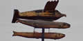 Chetwynd, like Hope, styles itself “Chainsaw Carving Capital of the World”. This enormous carving was gazing down on Chetwynd’s main road. We have nothing like that in Hope, fortunately.
We could have stayed on the main highway and continued to Dawson Creek, famous as Mile 0, the beginning of the Alaska Highway, but we’ve done that a few times and instead we were taking a more scenic short cut along the Peace River to join the Alaska Highway at Charlie Lake.
It was getting late and still drizzling so we took the easy option and camped at Moberley Lake, a provincial campground. The park has a lake and a campground and a few trails but nothing to tempt us to spend more time there.