2013/06 NWT trip - Hay River |
|||||
We set off east, stopping at an overlook of forest and the distant lake. We could see a very long way but there was no sign of a road or town or anything human. The viewpoint itself was a chaos of fissured limestone, not a place to be careless.
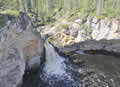
Nearby McNally Falls was a safer spot with a pretty creek dropping into pond, but surrounded by bugs as usual. I think I had finally sussed out those crazy giant flies. Officially they are giant horseflies, but historically there were no horses in the area. Instead, they’ve been dining on mammoths, caribou, and bison for millennia. They probably think the camper is a giant mammoth, so as soon as we’d stop there’d be dozens flying around the truck looking for a meal. If we were slow at getting out we’d be eaten too, but as soon as we were away from it they’d lose immediate interest. Stand still for too long and one’d take a bite, realize we are soft and juicy and from then on we’d be like heroin for that fly; it would end badly for both of us. The locals call them “bulldogs” with good reason.
We’d see people drive in, open the door and promptly close it again and leave, flailing at the dozen flies that had got inside; a shame as they are manageable. Once inside the vehicle they don’t bite, just want to get out. Mozzies on the other hand will bite anywhere.
 At Enterprise, not much more than a bump in the road, we turned north on NWT 2 towards the town of Hay River. We turned off at Paradise Gardens, a little community along the river, blessed by topsoil from river floods, and protected in the valley from the worst of
 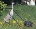 the weather. We could see where the gardens were but the major crop so far seemed to be dandelions. While I was checking out the beach Sandie spotted a couple of sandhill cranes around one of the houses. The cranes are normally skittish around people so these may have been pets, very unusual. This one needed to get on with the mowing.
The town of Hay River is just upstream from where the river flows into the Great Slave Lake. Hay River is a port and it’s also the northern terminus of the Mackenzie Northern Railway. The railway brings freight, mainly diesel fuel, up from Edmonton; the freight is loaded onto barges and pusher tugs take it from Hay River across the lake and down the Mackenzie River to towns in the western Arctic: Norman Wells, Tsiigehtchic, Inuvik, Tuk.
I was still looking for postcards but the only ones in town were of auroras and the town’s one and only high rise apartment block. We were assured though that we’d get them at Winnie’s in Enterprise and at the 60th Parallel welcome centre shop.
The campground is right at the mouth of the Hay River. It was warm in town but we had a cold wind off the lake, not surprisingly as it’s 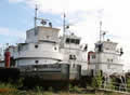 as cold as Lake Superior and the deepest lake in North America at about 2000ft. The beach looked like BC’s coast with tree trunks stacked on the sands by storms, forest reaching the beach, and gulls and an osprey overhead. Along the river was a line of pusher tugs looking mostly derelict.
Wednesday June 19th
It was a bright sunny morning. We found the heritage centre in the old Hudson Bay store, and spent an hour or two in the museum. 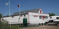 The curator, Vicky, seemed glad to have visitors who were interested in the rocks, artifacts, and the history of the area. We’d noticed that some of the houses were built on stilts, a reaction to the flood of 1963. An ice dam on the Hay River had created a giant lake, and when the dam gave way the flood tore across Vale Island and destroyed most of the houses; today the island is mainly industrial and the town has been relocated upriver to a safer spot, they hope.