2013/06 NWT trip - Wood Buffalo national park |
|||||
![]() We were off east along the lake to distant Fort Resolution, a hamlet at the end of NWT 6. We weren’t expecting a great deal, but we
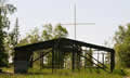
We were off east along the lake to distant Fort Resolution, a hamlet at the end of NWT 6. We weren’t expecting a great deal, but we ![]() were driving every other highway so we might as well do this one. It’s the oldest continually occupied place in the NWT, with some interesting buildings, like this ceremonial arbour, and a great view over the lake.
were driving every other highway so we might as well do this one. It’s the oldest continually occupied place in the NWT, with some interesting buildings, like this ceremonial arbour, and a great view over the lake.
 We drove the back roads beyond town to a beach and a weird-looking ceremonial site looking across the bay back to town. It was probably just the town’s annual picnic site. There was some new stuff but the old and empty buildings with an outhouse door banging in the wind gave it a real Stephen King flavour
.
We backtracked to camp at Little Buffalo River Crossing, but the campground was not very appealing so we thought we’d move on to Little Buffalo River Falls, a short distance upriver. It wasn’t a short distance by road! We traveled on for another three hours or so, taking NWT 5, the road into Wood Buffalo national park, passing what felt like a billion trees. We saw a single bison bull on our way in.
Along the road was an incongruous line of metal power pylons. Many of these carried large nests, some with black heads protruding – ravens, we thought. The pylons carry power to Hay River from a hydro plant on the Taltson River, way beyond the end of the road.

We stopped for a break at the Angus fire tower, a good place to spot wildlife I thought, but the ladder had been cut short. Nearby was a 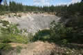 massive sink hole, a collapsed cave; this is karst/limestone country and prone to sink holes. Why they built the tower next to the hole I don’t know.
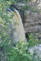
The territorial park at the falls only had six sites, and we were alone, just us and the bugs. The park had an unkempt look, little visited by anybody. The waterfall was hard to see with the sun behind it and the viewpoint was crumbly so we’d wait until morning.
 It was a long night; we were sharing the camper with too many mozzies.
Thursday June 20th
Oddly, the canyon wall was fully fenced but gaps had been left for us to get past it and take pictures or fall to our deaths. I bushwhacked my way to the upper falls, but they weren’t worth the effort. I found a somewhat grubby sign with a map of the trails and puzzled over it for a long time; it had been drawn from the viewpoint of someone on the other (inaccessible) side of the canyon. The trails were overgrown anyway.