2012/04 Sunshine Coast - Malaspina Peninsula |
||||||
Malaspina Peninsula |
||||||
Just before we left, a black bear appeared on the opposite bank, our first bear of the season but too far away for good pictures. We finished our walk and drove to the ferry terminal and were pleasantly surprised to find that our rather expensive ferry tickets 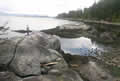 were actually returns. The ferry took us from Earl’s Cove between a couple of islands and under a very long set of power lines to Saltery Bay, the next piece of the mainland. Next door is the provincial park; its campground was also “closed” and not cleaned up after the winter storms, but the gates were open, another place for some free camping. We only had to clear enough
 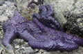 branches away to have a fire.
Good Friday began cloudy with a little rain. We went down to a rocky beach and a very low tide, low enough to expose many of the area’s purple and orange starfish. The beach is called Mermaid Bay, famous for the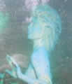 large bronze sculpture of a mermaid. My only picture is from a sign, as the sculpture’s submerged in 10 fathoms of water, viewable only by scuba divers. A few of them surfaced while we were there. By lunchtime we’d walked the beach and the only trail; it’s a small park and it was time for us to be moving on.
 We drove along the coast of the Malaspina Peninsula, mainly through forest; the cottages there are quaint, not as grand as those closer to Vancouver. We came to Powell River, a good sized town, and drove around it until we found the narrow greasy logging road that leads to Inland Lake park. (A silly
 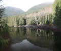 name for a lake. What other kinds are there?) It has a campground, quite busy with the locals, but they didn’t seem to be paying so nor did we. We walked around the lake to Anthony Island, passing this very strange totem en route. The bottom half is a diving orca, so that’s a dorsal fin sticking out there. I was about to write that the lake is nothing special, but like most BC lakes, it’s gorgeous with the usual tall trees and understory of salal and ferns, moss everywhere.

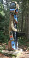
Saturday was cool and sunny as we drove back to Powell River to refill our only working propane tank, just in case. We’d discovered that our backup tank wouldn’t work even though it was full. We continued along 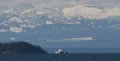 the coast road to Westview where we found this totem and this view across the Malaspina Strait to a ferry, the tip of Texada Island and the lofty mountains of Strathcona park on Vancouver Island. Down on the beach among the rocks is the ruin of a giant fish trap built by the Sliammon Indians. The tribe is still around, in a reserve further up the coast.
On the coast to the north is the Powell River paper mill, with its smoke rising straight up, an amazingly calm day for the area. The mill is owned by Catalyst, Stew’s previous employer. With the decreasing market for its specialist papers the company’s future looks bleak and either Port Alberni or Powell River could be badly hit by a closure of its mill.
The mill’s original owners had dammed the Powell River back in 1920 to create Powell Lake and generate electricity for their mill. The river itself is only a kilometer long, and nearly the shortest river in the world.
Sandie wanted fish and chips by the seaside, and we drove to the end of the main highway to the village of Lund, which hangs on the cliffside around Lund Cove. There’s enough space for a hotel. a pier, a bakery, and a restaurant, with little left for people or parking. Sandie got her shrimp at the tiny Boardwalk restaurant.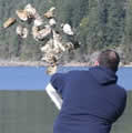
We drove over the hills to a park on Okeover Arm, another fjord, this one connecting to Desolation Sound. The 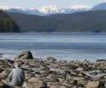 sound is more attractive than it sounds, but maybe George Vancouver named it on a wet day. It’s inaccessible without a boat, so all we could do was walk along the beach and gaze down the Arm towards it. There was a large family in the park enjoying an Easter oyster party. They’d harvested too many so the picture shows the extras going back in. We could have had them if we’d had a license.
We drove back to Saltery Bay to be close to the ferry. We used the same campsite and firepit and finished off our brats on what was probably the first warm evening of the year.
Easter Sunday began cloudy, a good day to be leaving. We caught the midday ferry over to Earls Cove. This strange looking 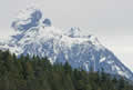 mountain appeared as we made the turn into Agnew Passage. It is Mount Churchill, one of a number with that name in North America.
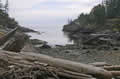 We were last off the ferry so it was a pleasant and peaceful drive. We weren’t joining the 50 mile race to connect to the next ferry, just looking for a nice spot for lunch. We drove to another park at Smugglers Cove but found it was a 5k hike to the cove so we settled for another nearby cove, its cliffs adorned by cabins and decks, but peaceful, with most of the occupants missing.
We were very early for the next ferry, but there was already a long lineup and we were lucky to squeak on. Interestingly we were the only motorhome in a sea of cars. We took the Lougheed Highway most of the way home, a nice drive on a quiet Sunday evening. Easter Monday is a bank holiday in Canada, so there was little truck traffic.
![]()
We set off for England on Tue 17th, using the same route as last year, flying from Bellingham to London via Minneapolis. We stop off there on our way back on May 1st and we fly back here on the 7th. John and Edna arrive here a week or so later, and we take off for a couple of months in the US Southwest, so we might be a bit slow with the letter writing for a while.