2012/04 Sunshine Coast - Sechelt and Skookumchuck |
||||||
Sechelt and Skookumchuck |
||||||
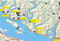 We’d had some repair work done on the camper and as we got into April we thought we should take it on a trip and check it out before this summer’s trip. There was no point in going anywhere inland as we could see that the snow line began at about the 500 foot level; all the campgrounds and trails would still be snowed in. So we picked the lowest elevation we could and headed for the beach. Vancouver itself is not really camper-friendly, but there is an area northwest of Vancouver called the Sunshine Coast. It’s part of the mainland of BC but because of mountains and many inlets from the sea there are no connecting roads, just ferries.
So that was the plan. Then all we needed was the right weather, but we had weeks of cold, wet, and windy and it wasn’t until the 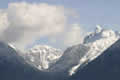 Wednesday before Easter that it looked reasonable for four or five days in a row. We drove to West Vancouver’s Horseshoe Bay and took the ferry. Like most BC ferry trips on a sunny day this one was scenic with the Coast Mountains towering over us. The ferry took us around Bowen Island to Langdale, a busy spot, and then we drove along the coast to Sechelt. This is a nice little town with two beaches, one facing Vancouver Island and the other the waters of Sechelt Inlet. Appropriately enough, Sechelt means “land between the waters”, great for sailors, but a problem at tsunami time as the land is only about a half mile wide.
 We drove a little way up the coast to Sargent Bay, a pretty park, squeezed in between some very expensive-looking homes. The area looks similar to the east coast of Vancouver Island, with few roads, and houses perched on steep mountainsides with kamikaze driveways. The Island’s beautiful arbutus trees thrive there too.
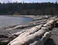
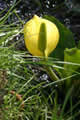
After a walk on the beach we went back to Sechelt Inlet and camped at Porpoise Bay. The campground was not 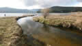 open but we could camp for free in the group campsite. It’s a great place for kids with a sandy beach and a creek burbling through, all ferns and moss and skunk cabbage. Out on the water
 ![]() we had mergansers, Barrow’s goldeneyes, and scoters with their strange looking beaks.
we had mergansers, Barrow’s goldeneyes, and scoters with their strange looking beaks.
On Maundy Thursday morning the Queen was busy handing out Maundy money, including groats and other strange coins, but we were driving the twisty road that leads to the next ferry terminal at Earl’s Cove. We 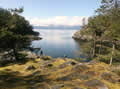 stopped for lunch at the Francis Peninsula, a convoluted piece of geography with coves and water at every
 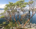 turn, as well as some spectacular houses, some like castles hanging off the cliffs and others spread across small islands. We walked through a tiny park to Francis Point and an absolutely delightful little cove, one of the prettiest beaches we’ve ever seen. The arbutus trees looked to be glowing.
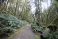 North of there the road goes through some rugged country, with large lakes amongst the mountains. We drove a little way past the ferry terminal to the end of the road and to Egmont at the head of Sechelt Inlet. This area is famous for the Skookumchuck Narrows, an area where rocks obstruct the tides. The water comes through the narrows at about 20 mph, hits the rocks and creates enormous standing waves, big enough to wreck a lot of boats over the years. It’s about a 5 mile roundtrip from the road through rain forest, mostly easy going and pleasant walking.
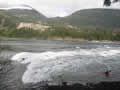 We arrived at Roland Point a while before the wave peaked and watched a sea kayaker and a group of
 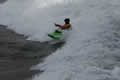 whitewater kayakers playing on the wave. The sea kayaker had a photographer there so it was a professional shoot. He was a very powerful paddler to make headway against the tide. The whitewater kayakers were there for the fun, dancing across the wave. Everyone pulled out for the wave’s maximum and then went back in. They were really happy to have me taking pictures and I’ve been e-mailing the results to them since getting home.