2004/07 Yukon trip - Trek to the Arctic - Dempster Highway and Tombstone Mountains |
|||||
We drove out along the Klondike River valley. The valley’s just a mass of rock piles, tailings from the dredges that used to work here and the placer guns that shoot high velocity water streams to loosen up the rock. Some of that is still going on, along with bulldozing and cranes and centrifuges, all with the objective of getting the gold out of the ground as cheaply as possible.
We turned north onto the Dempster Highway, and crossed the Klondike River, with just short of 500 miles to go to Inuvik. There is a gas station halfway at Eagle Plains but the first town is over 300 miles away. The road was two cars wide and good gravel at this point, but it was supposed to deteriorate in the north. We had trees all around us, but there were big, bare pyramidal mountains on the horizons. These looked greenish but had no trees.
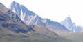
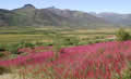
We camped at the Tombstone Mountain government campground. This is a nice spot, sitting 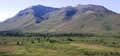 on a burbling creek, surrounded by head-high shrubs, and a few trees, and mountains all around. We went for a short hike and found a few flowers, and some enormous mushrooms that would feed a family. We had a good fire going to cook the bratwurst, but a cool wind set in at sunset, about 11.30.
 Thursday 5th August
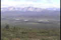
We had a cold night, especially as the furnace didn’t seem to be working! I fiddled with the 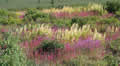 wiring in the morning and managed to get it working eventually. Then we set off north up the highway. All I can really say is that this is one of the great scenic drives. It goes through range after range of mountains, the Tombstones, the Ogilvies, the Taiga, most of the time following a river or creek, sometimes looking down on lakes. It’s comparable to the Icefields Parkway north from Banff, but without all
  that traffic. Some areas were forested, others were tundra, with just a mushy layer of bog above the permafrost. It is the kind of country where it’s easy to take good pictures: just point the camera in any direction, but it’s impossible to convey the feeling of actually being there with the scenery all around you.
Beyond the mountains are the Eagle Plains, gently rolling hills. That’s where we camped, just off the road, in the ![]() remnants of an old forest fire, with a good view out to the west. There aren’t many places to pull off this road, as parking on partially melted permafrost isn’t wise. We lost the sun for a few hours in the last mountain range, but it came back in late evening and so did the wind, whistling around the camper. Sunsets take forever at this latitude and we still had red sky remnants of this one long after midnight.
remnants of an old forest fire, with a good view out to the west. There aren’t many places to pull off this road, as parking on partially melted permafrost isn’t wise. We lost the sun for a few hours in the last mountain range, but it came back in late evening and so did the wind, whistling around the camper. Sunsets take forever at this latitude and we still had red sky remnants of this one long after midnight.
| Dempster Highway (1.10) |
 |
|---|
Friday 6th August
It got cold last night but luckily the furnace worked properly this time. We awoke to blue skies and sunshine and it was already as warm as the best of yesterday. The scenery was less exciting as we were driving mainly through spruce bog with little to look at other than low straggly spruce trees. Eventually we came to the Eagle Plains Hotel, similar to the roadhouses in Australia. The gas was being pumped by a native of Toowoomba in Queensland who was a bit surprised to find someone who’d actually been to Toowoomba. She was on a working holiday of Canada, making her way across country. We were pleased that the gas wasn’t as expensive as we’d feared, as they have a monopoly: very few vehicles can make the 460 mile Dempster Highway trip without filling up here at the halfway point. However, they take the prize for the most expensive quart of milk we’ve ever bought! But then we haven’t seen a cow in a long time.