2004/07 Yukon trip - Trek to the Arctic - |
|||||
We bounced our way 60 miles back to the main highway where we turned east towards Dawson City in the Yukon. The last dot on the map before the border is Boundary which is just a gas station. The guy was taking full advantage of being the only gas station in over a hundred miles. We declined to buy at his prices, higher even than Eagle’s. We found out later that his cash register had broken so he’d rounded the price up to the next full dollar to keep the arithmetic simple.
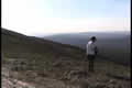
We crossed into Canada with no problems. The road from there on was partly paved and partly gravel, much better than the road to Eagle. It’s called the Top of the World highway, and that’s what it feels like as it runs along a ridge of mountains with forever views on either side.
| Eagle & Top of the World (12.42) |
 |
|---|
Sandie counted ten ranges of mountains that we could see on each side. The road has a bad reputation but I suspect it’s mainly because people focus on the scenery and forget to slow down for the next bend. The nearest road to the south of us was the Alaska Highway. The nearest road on the other side was somewhere in Russia, on the other side of the pole.
![]()
The amazing thing was that it was absolutely still on top of this ridge, no wind, and in the 60s until near midnight. We camped in a gravel pit just off the road, and it was so quiet we could hear the wings beating when birds flew over.
Wednesday 4th August
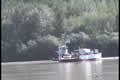
We dumped all the water we had got from Eagle. As Sandie said, it was full of sludge, tasted bad, and made her sick, so we’d have to fill up again in Dawson. We came to the Yukon River again, and took the ferry across to Dawson City.
| Yukon Ferry (2.41) |
 |
|---|
In case you’re getting geographically confused about the Yukon River, it starts near Skagway, only 16 miles from the sea, but on the east side of the mountains. Then it flows north to Whitehorse, further north to Dawson City, northwest to Eagle, and then mainly west right across Alaska. When it hits the Bering Sea after 1000 miles of travel it’s about 60 miles wide.
Dawson is at the junction of the Yukon and Klondike Rivers and it grew up during the Klondike gold rush. It used to be the capital of the Yukon, but lost that to Whitehorse. Its business now is gold and tourism. Most of the old buildings are still there, and the streets are still gravel and mud with wooden sidewalks. There’s a sign in the library asking patrons to remove their shoes before entering.
We were going to be off in the boonies for about a week so we were visiting Dawson just to load up with food, water, gas, etc. We wanted to hit the Arctic while the weather was still good, so we postponed exploring Dawson and the gold fields until we came back.