2004/07 Yukon trip - Trek to the Arctic - |
|||||
We stopped at the Eagle River, where the Mounties caught up with the Mad Trapper and killed him in a shootout. The Mad Trapper story is one of the few pieces of documented history in this area. He fired on the Mounties that came to question him about trap robbing, and that led to the historic manhunt. Every town seems to advertise its own little part in the story.
We also tried to remove all the agates from the river while we were there. We were rummaging again in the shale rock of a road cut a few miles further on and Sandie found part of a fossil plant stem, nothing spectacular, but nice to add to the collection. The road builders used this same rock to build a 50-mile section of the highway, as they had nothing else available, and it’s very sharp and notorious for puncturing tyres, so the locals all warn you to go slow for this whole section. However, they all seem to blast along it at 60 mph anyway! The road is built several feet thick here to insulate the surface from the underlying permafrost in the hopes that the permafrost won’t melt in the summer. If it does then the road buckles and breaks when it refreezes in the winter. It seems to work as the Dempster was much more level than the roads in Alaska.
 We finally came to the Arctic Circle at 66˚ 33′ latitude. Everywhere north of here experiences 24 hours of daylight and the midnight sun for at least one day of the year. There is an information board and a place to take pictures. Fortunately it happens to be in a very scenic spot with a backdrop of the Richardson Mountains. Even better it was sunny and about 65 degrees. We were there for a while, eating lunch and dialing in to the Internet, so we saw a succession of people coming in to pose in front of the board. There was a motorcyclist from Saskatoon who’d had a grandfather in Agassiz and had lived in Hobart, Tasmania. There was also an elderly lady who carefully placed a blue plastic box in front of the board and then took its photograph from various angles. I didn’t want to ask what was in the box.
 Further on, partway into the Richardson Mountains we crossed into the Northwest Territory and left the Yukon behind. We then had a long period of bouncing through mud. There is only one road so when it is being fixed the traffic has to drive through the roadworks and share the road, or in this case the mud. The scenery was great though while we were bouncing, great smooth rounded and treeless mountains in a mixture of colours and shapes, and cliffs with dazzling rock patterns, a very visible geology lesson.
We crossed the Peel River on a ferry and took a sunny campsite at the Nitainlaii Territorial Park, just short of Fort 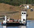 McPherson. At 9pm we were being cooked in 75 degrees. So much for the frozen north!
North West Territory (Fort McPherson, Tsiigehtchic, |
|---|
Saturday 7th August
Another sunny morning and we went first to the visitor centre to learn how to pronounce Nitainlaii and to find out about the Tetlit Gwich’in people. They used to be nomadic moving around to wherever the food was: caribou, fish, muskrat, berries, and it was the Canadian government that insisted they live permanently in towns so they could take advantage of schools and services. Even so, they still leave town for their summer and winter hunting camps. They were a pretty tough people to be able to survive the winters here in moose-hide tents, even if they were double-walled.
They now live at Fort McPherson in a typical Indian town: some of the houses neat and tidy, others looking ready for demolition. We stopped there to buy gas, use the post office, and visit the sail and canvas store. The owner there admitted that he was a ten-monther, leaving in December when it became dark for 24 hours a day, and returning in February. He would go south to Winnipeg, which still doesn’t sound very south to us! While we were there the power went out. “Happens a lot”, he said, “ever since they burned the power plant down.” Many of the houses here are built on stilts. It looks like they’re getting ready for the next great flood, but the stilts are there to protect the permafrost from the heat of the houses. If they were simply built on concrete slabs then the permafrost underneath the slabs would melt and the houses would bend and crack. We have to assume that they have awesome amounts of insulation in their floors.