2015/11 Australia trip - Brachina Gorge |
|||||
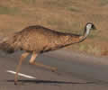 Dodging emus and roos again, we hurried back to Brachina, to claim one of the campsites. There was a signpost to the “4wd sites”, though
 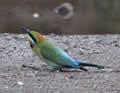 in our opinion if you didn’t have a 4wd’s clearance then you wouldn’t have made it to the campground at all. The track went along the mostly dry creek bed and then climbed up onto the opposite bank. The site was just perfect, ringed by gigantic river gums looking out onto a lush floodplain, kangaroos all around, corellas flitting overhead, one of the prettiest campsites we’ve ever had. We had the place to ourselves.
Thursday November 12th![]()
We awoke to thunder and lightning, with the storm really close by. When the rain started we began packing up in a hurry. Pretty as the place ![]() was, we didn’t want to be stuck there by a creek bed full of creek!
was, we didn’t want to be stuck there by a creek bed full of creek!
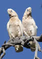 Luckily the rain soon stopped and we didn’t see any water flowing down the creek. We took a walk along the creek bed in the beautiful morning light before we finished packing up. These are a few of the birds we saw: a willie wagtail, a couple of falcons, a woodswallow
 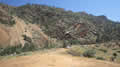 perhaps, a dotterel, and this pair of corellas.
We drove into the gorge along the creek bed. There’s a track of sorts where there’s sand but there’re also rocky sections and lakes to drive through. In places the river is still flowing, emerging through the sand and then disappearing back into it. This is where the 4wd can get a real workout!
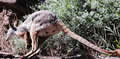
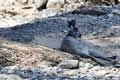 We spotted some yellow-footed wallabies in the gorge, identifiable by their striped tails and the way they climb the gorge’s walls. While wallaby watching, we talked to a couple who’d just driven up from Wilpena; they said that the storm had been torrential there with flooding in a few places.
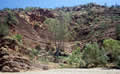
The geology of the gorge is fascinating, a part of the Brachina Gorge geological trail. The rocks date from around 500 ![]() million years ago, about a dozen different kinds of sedimentary rock laid down in an orderly fashion, conforming as geologists say, and then the whole shebang was crumpled by plate movements. And the whole area was salted once by the impact of a colossal meteor. Erosion has exposed the crumples of a rainbow of coloured layers. The whole area is called the Adelaide Geosyncline, and part of it is visible in this gorge wall.
million years ago, about a dozen different kinds of sedimentary rock laid down in an orderly fashion, conforming as geologists say, and then the whole shebang was crumpled by plate movements. And the whole area was salted once by the impact of a colossal meteor. Erosion has exposed the crumples of a rainbow of coloured layers. The whole area is called the Adelaide Geosyncline, and part of it is visible in this gorge wall.
There are signs all along the trail indicating which layer is currently exposed. This naked geology reminded me of parts of Utah and Wyoming, particularly the drive into the Flaming Gorge, which also has signs identifying the geological layers.
I was rather hot in the gorge, and Sandie was not feeling well. We came out to the park boundary, and could have made our way south from there but there was no shade from the strong sunshine, so we went back through the gorge, looking for a shady lunch spot. Later, we drove the rest of the geological trail, checking out any campsites we encountered.
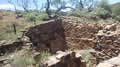
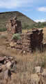
The road to Aroona was supposed to be suitable for 2wd but it had a steep washout right across it, and we almost got hung up on the drop. Aroona is the site of a spring and for a while it was a very successful sheep station back in the 1850s, but it was wiped out later by decades of drought. All that remains are foundation ruins up on the hill next to the spring. We just made it back up and over the washout; very glad we didn’t have to get the shovel out and fix the road!
 The ruin at Youngoona was easier to get to, but it was only the site of a shepherd’s hut, owned once by Aroona station, and not much more than the fireplace survives.
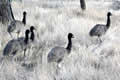
We had to visit Wilpena again for some shopping and we returned via the Bunyeroo Gorge, now mostly underwater after the morning’s rain. We camped amongst the gums at Trezona, another campground next to the dry bed of Brachina Creek. It has a dozen big campsites, all empty so we only had to share the place with a couple of emu Dads and their large families.
After such a hot day, we had a surprisingly cool evening.