2015/11 Australia trip - Bunyeroo Gorge |
|||||
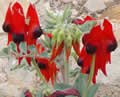
 We drove northeast through Quorn and Hawker; both places looked quiet and the caravan parks there were almost empty, a good sign for us as the park would likely be quiet too. We spotted these Sturt’s desert peas outside a building in Hawker, not as spectacular as the mass bloomings we saw up in the Pilbara on our 2006 trip, but nice to see them again.
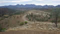
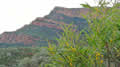
We now had mountains on all horizons, all part of the long Flinders Ranges, which stretch for a few hundred miles north from Point Pirie. We entered the national park and started looking for a campsite. We passed signs for Wilpena Pound, the park’s most famous destination, but the campground there is a “resort”, not really our thing.
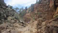
The entry boards had fee envelopes but no maps that we could take with us. We took the first side road we found. It began as an average gravel road but soon became rough as we drove over the “Razorback”, a high ridge, and then a 4wd track when we dropped down very steeply into the stream bed of Bunyeroo Gorge. This was all interesting stuff but we were running out of daylight. Slowing us down even more were roos, emus, and rabbits all over the road.
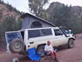
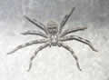
To our relief we found the Acraman campground, surrounded by mountains and cypress-pines, not really pines but they look similar. We even had an outhouse, guarded by this cute spider. It was warm and overcast, pleasant for sitting out. As you can see, I’d had to revert to pen and paper after the failure of our laptop.
Wednesday November 11th
The Acraman campground was OK but we thought we’d look for somewhere more interesting for the next night, so we drove further along the road. The Cambrian campground, a few miles further along, was interesting but only because it was hard to work out what was road and what was campsite; it looked like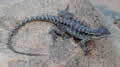 it was designed for confusion and collisions.
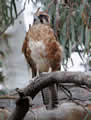
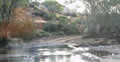
Further along was the entrance to Brachina Gorge, hard to get into as the road had obviously been washed away many times, but it looked to be ideal, with campsites perched on the banks of (mostly dry) Brachina Creek. This was where we’d camp that night.
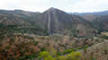
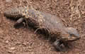 We then backtracked the whole road, taking our time and exploring. There were fewer animals to see at midday, mostly lizards and birds like this little falcon. But there was some dramatic geology on show in the Bunyeroo Gorge and plenty of flowers and views of cliffs and mountains from the Razorback.
 The park’s visitor centre is in Wilpena Pound, and part of the resort. There was lots of souvenir stuff around the walls for sale but I had to ask the ranger for a park map. He seemed surprised that I wanted one. It seems to me that a basic map should be easily available; this is dangerous country to get lost in.
Sacred Canyon was the closest place of interest, a narrow canyon and a warm spot on a sunny afternoon. It’s home to a collection of petroglyphs, mainly circles chipped into the rock.
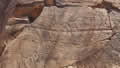 The waterfall at the head of the canyon had dried up and I climbed partway up, and found more circles up there. We had the
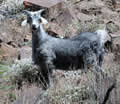
 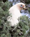 canyon to ourselves, but we could hear weird wailing noises. We thought it might be cows but later realized it was coming from feral goats.
The previous evening we’d hurried past signs for other trails so we went back south to check them out. Most interesting looked to be the hike up to Arkaroo Rock. The signs disagreed on the length of the trail up to the rock, and it turned out be steep with large steps up.
The climb took us up to an eroded boulder that looked to be covered with modern graffiti, rather disappointing, but there was arrow pointing further up the hill. There we found a similar rock with its interior protected by an iron grid. Inside were these pictographs, quite well preserved, probably because they were in the shade. We were tired out by the time we got down, but it was getting late anyway.