2015/10 Australia trip - Little Desert |
|||||
Monday October 5th
We were up early, sorting out what to take; we’d forgotten how much stuff we already had in the closet, like my hiking boots left behind in 2010. We filled the camper and were relieved that we could get the doors closed and could see out the back window; we’d sort out how to live amongst it all at our first campsite.
John had leant us their massive free campgrounds book. We also had downloaded a campgrounds app onto Sandie’s tablet. We’d bought a used Australia chip for our Garmin GPS and John had already installed a Tomtom GPS in the Troopie; two GPSs was overkill but a second opinion might be useful.
We said goodbye to John and Edna; we’d be back in about seven weeks. John had lent us some Australian money to tide us over until our cheque cleared at the end of the month, and we stopped at the bank to deposit it so we could use Australia’s EFTPOS debit card system on our trip. We also tried to get a Telstra SIM card for one of our phones but both were locked, so we gave up. We could have found someone to unlock them but it was not that important; we’d be out of cell phone range for most of the time anyway.
 Our drive across Melbourne and through the tunnel under the Yarra was easy, no jams. Our route took us along the Western Freeway, much improved and lengthened since
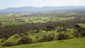
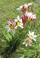
 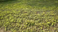 our last trip this way in 2006. This is largely flat farming country, green in the spring, until we approached Ballarat, a gold rush town, and then Ararat. Despite the Biblical name there was no sign of an Ark, but the town does have a little ridgetop park with a beautiful view over the valley to the Grampian Mountains where we camped with John and Edna and her brother Colin back in 2000. These flowers were up on the ridge; they didn’t look to be native Australian plants, but pretty all the same.
 We were headed for the Little Desert national park where we’d camped and froze in the winter of 2006, early June I think. Our GPS instructions led us from Dimboola into some interesting dirt roads but we ended up making a complete loop back to Dimboola before we turned both GPSs off and just followed the road signs. We suspected that both GPSs had the same problem we’ve seen in Canada: the roads within the parks are not included in the national road network, so the GPS thinks that all it has to do is get us as close as possible to a piece of the park, regardless of whether
there’s any road at that point. However we later found that once we were on a park road the GPS often recognized and named it so maybe it’s all a plot to get us to buy the “topo” or “4wd” chip as well as the “streets” products.
We were headed for the Little Desert national park where we’d camped and froze in the winter of 2006, early June I think. Our GPS instructions led us from Dimboola into some interesting dirt roads but we ended up making a complete loop back to Dimboola before we turned both GPSs off and just followed the road signs. We suspected that both GPSs had the same problem we’ve seen in Canada: the roads within the parks are not included in the national road network, so the GPS thinks that all it has to do is get us as close as possible to a piece of the park, regardless of whether
there’s any road at that point. However we later found that once we were on a park road the GPS often recognized and named it so maybe it’s all a plot to get us to buy the “topo” or “4wd” chip as well as the “streets” products.
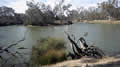 The campground is on a big loop of the Wimmera River, which is lined with red river gums, great gnarled trees, gorgeous but notorious for spontaneously dropping limbs and
 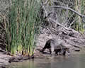 taking out tents and campers. We walked a few sections of the river bank, but we weren’t enjoying it a lot. The afternoon was very hot and windy, but the major problem was the flies; these were the classic outback flies, tiny and not biting but desperate for moisture so they head for eyes, nose, ears and the corners of your mouth, and very irritating. Despite all this we spotted quite a few birds and this aged kangaroo that came down to drink at the river’s edge.
I hadn’t recognized any of the park so we must have camped in another section back in 2006. The camping fees this time were $37, about three times the price of other parks, presumably because it’s within range of Melbourne. Instead we headed back to Dimboola, found the next rest area, and drove into the bush behind it to camp. We  could hear distant traffic but couldn’t see any other campers.
Sandie cooked omelets; the flies were a problem until dark when the moths and weird crunchy things took over. The night was hot enough that we assembled the roof bed and slept one up (Sandie) and one down.