2015/03 Hawaii trip - Kilauea helicopter flight |
|||||
 Thursday March 5th
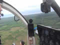
On a clearing morning, I was off early to Hilo’s airport to find Paradise Helicopters, a company that takes passengers on flights over Kilauea’s lava flows. They use Hughes 500 helicopters, developed originally for military observation. As a special treat they’ll do the trip with all the doors removed, a bit draughty but great visibility. I had the seat next to the pilot with the same view as him. It was not really Sandie’s thing, with nothing between your elbow and the ground, so she was sleeping in.
| Heli to Pu'u 'O'o (12.56) |
 |
|---|
The pilot, Reese, took us over Keaau and the cottage, and a few miles further on to where the lave flow had been threatening Highway 130 and the Malama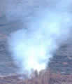 market. I was shooting video most of the time but using the video camera to take snapshots too, like the one at the beginning of this letter, the one that shows how close the lava flow got to the shops. The lava was mostly black, which meant that it had cooled somewhat, good news for the people of Pahoa.
Off to the west I could see smoke from a few hot spots, like the one in the picture. Although most of the flow had cooled there were “break-outs” where molten lava was still flowing and burning the vegetation.
| Heli Pu'u 'O'o crater (5.01) |
 |
|---|
I tried to take close-up pictures with my big long lens but found that poking my lens out beyond the windshield was a bit like trying hand 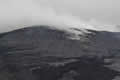 signals on a motorcycle at over 100 mph; your arms don’t end up where you expected!

We followed the lava flow up the hill and saw more breakouts, broadening the lava field. The new lava was silvery, just a skin over the hot lava with the molten rock just below.
 We came to Pu’u ‘O’o, the cone we’d seen on Monday, and the source of all the recent lava flows. Our pilot flew in tight circles at extreme angles over the crater, with steam obscuring the crater floor but we had glimpses of the hot stuff below. There appeared to be an orange lake of molten lavaand a more vivid red spot that looked to be spitting and churning. At one point I was hanging from the helicopter and feeling the heat radiating from the lake, but my harness held up well and I didn’t make a Gollum exit.
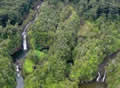 We flew back over Hilo and up the Wailuku River and it became clear that the waterfalls we’d seen the previous day were only a tiny part of the picture. There were many more streams and rapids and falls, mostly following collapsed lava tubes according to Reese. It looked
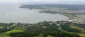 to be very difficult country to cross, explaining why Hilo has few roads connecting the north and south parts of the city. The other picture shows Hilo Bay and its breakwater. The city of Hilo is off to the right; the waterfront is mostly green, housing city and state parks. This was where we were planning to be on Sunday morning.
| Heli return to Hilo (10.14) |
 |
|---|