2013/06 NWT trip - Wadlin Lake |
|||||
 Monday June 24th
It was already hot again when we set off across the 60th parallel into Alberta. Bulldog flies had filled up the cab the previous evening when I was getting the firewood out. With the morning’s heat they were in a frenzy, seething around the dash and windshield. It looked like a scene from a horror movie. I should have taken a picture, but all I have is this single bulldog, and you’ll have to imagine them wing to wing all over the windshield. There were more outside fighting to get in, so all we could do was wait until we were moving faster than them, then open the windows and set about the residents. Does driving with a swatter in hand contravene Alberta’s “distracted driving” statute?
The Alberta road looked much the same, just mowed a little wider than in the NWT. The first town, High Level, was 120 miles south, a place to fill up. The road had traffic, with a truck every few minutes, our busiest since the Alaska Highway.
We turned off the main road there and headed east for our camping destination near Fort Vermilion. We found we were passing close to Machesis Lake so we detoured there for lunch through a classic Alberta gridwork of farm roads. All the “township” roads go E-W and the “range” roads go N-S, and they have totally forgettable names like 108-2. It sounds simple but bits of the grid are missing and it’s easy to end up at a dead end.
The farms seemed to be growing canola and winter wheat, at about the northern limit of the farmable area known as the Peace Country. We saw our first cattle in weeks, rangy beasts with impressive horns; presumably needed to fend off the wolves from the nearby Wood Buffalo park, which extends into Alberta.
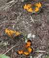 Machesis Lake looked just like one of the lakes up at Voyager Village, even down to the beach houses and dock and the sounds of distant loons. A nice lunch stop. On our way out through the grid we passed through an Indian reservation and came upon an isolated cemetery, with very strange graves. Each was topped by what looked like a small white coffin lying on the grave.
I’d planned to camp at the Fort Vermilion recreation area, overlooking the Peace River. We followed the signs and ended up at the Bridge campground. It was free but had no river views, just legions of mozzies, so we moved on. Fort Vermilion itself is a tidy little town on the shore of the Peace, named after the yellow ochre in the area.
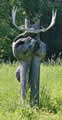
We set off south looking for an alternative campsite at Wadlin Lake, along a very quiet main road. Wadlin Lake is on an Indian reservation about 12 miles through dense forest down a very dodgy road with loose gravel on soft sand, rather like driving on ball bearings. This carving was outside the only house we’d seen in hours. I wasn’t expecting much of the campground, but it turned out to be large and very tidy, almost military, and nearly empty. It’s a fisherman’s lake, shared with pelicans and loons.
The temperature had been diving since High Level, now in the teens (50s F) and raining steadily. We’d finally left the bulldog flies behind but the mozzies were out in force.