2013/06 NWT trip - Twin Falls Gorge |
|||||
 We set off on our journey south, nearly 1000 miles to Okotoks. But our first stop was in Enterprise at Winnie’s gift shop and café. Sandie was looking for local crafts and I was still looking for those waterfall postcards. “I have some” she said, pulling out boxes and rummaging through drawers. She treated us to coffee while she searched. Soon the place was alive with grandchildren and Winnie was serving Saturday lunch to her family; she’s obviously still the family’s powerhouse. Eventually Winnie admitted defeat – no cards.
We drove a little further on to the Louise Falls campground, a spot we could use as a base for visiting all the waterfalls of the Twin Falls Gorge of the Hay River.
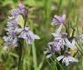
The woods were pretty with flowers, including yet more orchids. From the rim of the gorge we could see the tannin-stained water swirling 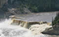 over the falls but for a really good view we climbed down a spiral staircase into the gorge. The falls are oddly rectangular and I thought their name should be Doorstep Falls, what your front door looks like if you forget to turn off the bath taps.
There was a pause for me to recover, probably a combination of dehydration and too many bug bites; the backs of my knees had swollen up. But then we were off through the woods along the gorge towards Alexandra Falls. We’d already noticed that the map of the gorge was the wrong way round, but worse was to come. The trail was decorated with expensive-looking drum-shaped interpretive signs describing an Indian band’s portage around the two sets of falls down towards Tucho, the Great Slave Lake. They were well done but had been placed in the wrong order! Even the two that included the “you are here” logo were in the wrong places. Somebody had good ideas but someone else messed them up.
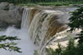
As we approached the Alexandra Falls, we met a sign telling us that the trail had been undercut, so we somewhat unwillingly took to the detour, a sunblasted trail along the road, but then we saw that the original trail had completely gone, all dropped into the river. The overlook of the falls looked to be on its way too, with railings hanging loose and the whole platform at an angle. These were straight line falls thunderous with spray.
We had a bad night with mozzies lurking inside. The question is how did mozzies evolve to cause maximum distress? If they all attacked when you turned out the light, then it would all be over quickly, but they seem to wait until you’re almost asleep, then one will fly around each ear and brush your nose before settling down to feed and getting smashed. Then the next one wakes up and repeats the whole process. Does the female mosquito’s deathscream wake up her sister? PhD for somebody there.
Sunday June 23rd
It was an even hotter morning, and hadn’t really cooled down overnight. We set off the other way down the canyon to go see Escarpment Falls, about a five mile round trip according to the goofy map. The first surprise was that there was a seat on the trail with a perfect view of Louise Falls. I doubt if one visitor in a hundred sees that view, as there’s no clue that it’s there.
![]()
The trail was similar to the previous day’s, winding through spruce and aspen and birch, with a carpet of roses and bunchberry flowers. The colour of the roses were varied, some dark pink, some with light or dark centres. Sandie found the Yorkists’ corner where they were all white.
The theme of the drum signs this time was a local medicine woman and her use of local plants; at least the order didn’t matter!
The second surprise was that no one had cleaned up the hundreds of downed trees that blocked the trail, making it a tiring hike. Our third surprise was that the trail stopped at a group camp site and where it should have continued the short distance to the falls there was a nest of danger and “unstable ground” signs. Best description of the terrain would be “sliding cliff”. That part of the trail had never been built but no one had thought to correct the signs. On our way back I counted over 250 step overs, walk arounds, and duck unders, 500 for the whole hike!
It was too late in the day for the 250 mile drive to our next stop, in Alberta, so we went just to the Welcome Centre at the 60th parallel. We’d been told about the shop there, but we suspect that the people had never actually seen the place. There was a nice little display of Indian crafts, some with price tags, but nothing was for sale and there were no postcards and no shop! We paid for camping and found a spot close to the Hay River, a more peaceful section this time, with beaver and geese around.
We went back later to use their Wifi. Karen had sent us details of the road closures due to the floods, useful as the local radio reports hadn’t mentioned that so many bridges had gone. School in Okotoks had been cancelled, ending a week early, so she asked us to arrive early if possible. If we’d been able to read our email this morning then we could have skipped the long and difficult hike and gone straight to our next stop, but it was unlikely now that we’d be early. We cooked over a fire to reduce the heat in the camper, but the area cooled down quickly when the sun set around midnight.