2013/06 NWT trip - Nahanni and Virginia Falls |
|||||
 Tuesday June 11th
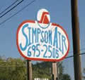
We were off early to the visitors’ centre to find out how to get to Virginia Falls in the Nahanni; they recommended Simpson Air, just down the road. We found that a tour group had already gone out that morning but the plane had been full anyway. If we wanted to go that day and actually get to hike to the falls, we would have to charter their other float plane. Needless to say, this wasn’t cheap, but it’s a place I’ve wanted to see for decades, and the weather was absolutely perfect. What I would really have loved to do was to raft down the South Nahanni from the falls but that would be an order of magnitude more expensive as well as tough on the body!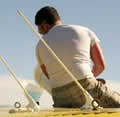
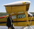 Simpson Air operates from a trailer next to Fort Simpson’s airstrip. We had to wait there for our pilot, Dean, to come back from a routine taxi run, their main business, and then he drove us down to their Mackenzie River dock. Another pickup brought a barrel of fuel. We waited on the dock while they tried to pump fuel into our Cessna 185, but apparently everything had been moved about when the river level dropped and the pump wasn’t working. They filled the tanks with a bucket and funnel. “Real bush plane experience” says Dean.
To get into a float plane you have to walk out on the floats and hoist yourself in, me first as I was in the back seats, 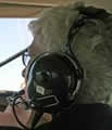
![]() then Sandie and Dean. Take-off and landing on calm water is much smoother than on a hard runway. The engine is very noisy so we wore headphones for communication. Dean kept up the commentary; he was guide as well as pilot.
then Sandie and Dean. Take-off and landing on calm water is much smoother than on a hard runway. The engine is very noisy so we wore headphones for communication. Dean kept up the commentary; he was guide as well as pilot.
| Up the Nahanni River (17.38) |
 |
|---|
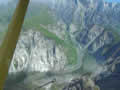
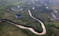
To our surprise Fort Simpson is on an island; the Liard splits around it, even more water than I’d thought. Most of the country nearby is 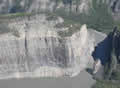 boggy muskeg, with thousands of lakes, but there were straight lines to be seen, cut into the surface by seismic testers looking for oil and gas. If all else fails pilots use seismic lines to find their way. We could see mountains in the distance in the Nahanni Park Reserve, an area almost the size of Switzerland; there are no roads, just a few places where splash down is permitted.
We followed the South Nahanni River up through a series of spectacular canyons. The picture is of Pulpit Rock.
boggy muskeg, with thousands of lakes, but there were straight lines to be seen, cut into the surface by seismic testers looking for oil and gas. If all else fails pilots use seismic lines to find their way. We could see mountains in the distance in the Nahanni Park Reserve, an area almost the size of Switzerland; there are no roads, just a few places where splash down is permitted.
We followed the South Nahanni River up through a series of spectacular canyons. The picture is of Pulpit Rock.
Dean told us about prospectors who had battled their way upstream, the disasters and crimes, and the headless corpses; gold was never found, which is why the area is still wild. The Nahi, a nomadic people who hunted in the Nahanni mountains, eventually settled and became today’s Dene. One tribe is believed to have left when earthquakes blocked their canyons, and they migrated far to the south and became Arizona’s Navajo.
| Virginia Falls flight (3.51) |
 |
|---|
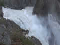
 After a hundred miles or so we could see the falls in the distance, a bright flash of turbulent water above a cloud of spray and a rainbow. As we got closer, the scale became clear, three hundred feet high, nearly a thousand wide, split by a mighty fang of rock. We swooped in over the lip and splashed down above the falls, motoring across to a dock. The tour group’s plane was still there,but they were leaving, trooping past us as we were having lunch.
 |
|---|
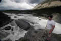
We followed a boardwalk trail to the beginning of the Sluicebox above the falls. There is a small island there, piled high with logs. Dean told us about a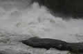 pilot
pilot 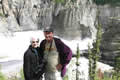 whose engine failed on takeoff; he steered the plane into the log jam, swam to shore with a rope, reeled the plane into shore, fixed the engine and flew home. Sandie and I nominated Dean as our swimmer if our engine failed.
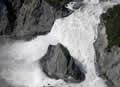
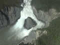
There is great turbulence just over the rim; the water explodes into the air, much more violent than Niagara. The trail ended just past the falls, where we could look down into the mist and the Painted Canyon below us. There is another canoe portage trail that goes to the bottom of the falls but that would have taken a few hours.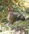
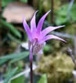
The rocks around us were full of marine fossils, and the woods had strange plants, but Dean was no botanist so we’re still sorting out what they were. Eventually we ran out of time and had to take off, fortunately without incident.
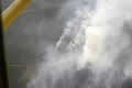
Our route back was going to take us over the Ram Plateau, with another splash down at Little Doctor Lake. For a while we thought we were heading into rain, but then we realized that it was smoke; there was a forest fire around Clearwater Creek, probably started by lightning. Dean called it in but thought that, as it was inside the park and so remote, it would be allowed to burn itself out.
| Ram Plateau (13.52) |
 |
|---|
We were on the lookout for wildlife particularly sheep, but they were impossible to spot against a landscape mottled with snow. Dean 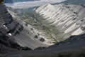 said that Fort Simpson was having trouble with wolves coming into town and eating pets.
The canyons of the Ram Plateau were both scenic and convoluted, very difficult country to cross on the ground.
But some people did; the Kraus family lived in the Nahanni for decades, building cabins as they moved around. When the park was created they settled just outside at Little Doctor Lake, our next stop. Eventually, the owner of Simpson Air bought the property and now rents it out to groups, mainly hunters and fishermen.
| Little Doctor Lake (4.38) |
 |
|---|
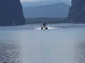
![]() It’s a beautiful lake, approached by flying through “the Gap”, with rocky cliffs on either side. From there it was a straight run across the
It’s a beautiful lake, approached by flying through “the Gap”, with rocky cliffs on either side. From there it was a straight run across the![]() muskeg to our splash down on the Mackenzie River, about six hours after takeoff.
muskeg to our splash down on the Mackenzie River, about six hours after takeoff.