2013/06 NWT trip - Fort Simpson |
|||||
We saw a small truck as we were leaving and that was the only vehicle we saw for the rest of our trip along the NWT part of the Liard Highway, three vehicles altogether in two days. There are no side roads, so the only coffee spots are by the mud holes where the road graders fill up their water tankers. We noticed that the trees in these spots were often tamaracks, pretty with their lacy light green fronds. They’ll look their best though when they turn gold in the autumn, which might mean early August in the NWT.
![]()
We came to NWT 1, also known as the Mackenzie Highway, and headed north towards Fort Simpson, now on blacktop. This road wasn’t any busier with traffic. We met a black bear ambling along the yellow line in the middle of the road. It looked surprised to see us 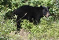 but was in no hurry to get off the road, or even to hide when we caught up with it.
Along the road we saw these strange signs and realized that they related to the thickness of the ice and whether cars or trucks could use the ice road. In summer the signs read zero thickness and there’s a ferry across the Liard River to Fort Simpson. Only when we got to 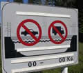 the river, there was a “road closed” sign at the edge of the water, not good. We weren’t sure what to do until an Indian came over and told us that the ferry had a broken prop shaft; if we were in a hurry he’d take us across in his boat. Estimated repair time was another four hours, so we found a spot to eat lunch and wait it out. I soon found that the big black flies buzzing around the vehicles were hungry and had big teeth; if they bit there’d be blood running from the wound.
Eventually other traffic arrived and started to line up so we joined them. One pair of travelers had begun their journey in Atlanta, Georgia years ago. As they only had two weeks’ vacation a year, they’d pick up their camping unit each year, drive and visit for a fortnight, put the unit in storage and fly home. This year they had started in Northern Alberta and hoped to get to Anchorage. They were leaving NWT along the Liard Highway. The ironic part was that they were only going to Fort Simpson to pick up fuel; they didn’t have enough to get to Fort Liard, so they too were stuck until the ferry was fixed.
It turned out that the ferry had been broken for over 24 hours, but news travels slowly in the NWT. Drivers would show up, park their cars, and either go across in the Indian’s little boat or call for a helicopter to come and get them. The ferry was fixed about an hour late, but then we had to watch it go through its safety testing for another hour.
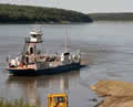
Getting on and off isn’t simple either. The river level goes up and down, so there are bulldozers on each side to sculpt a sand ramp to the day’s level. I would imagine that small cars often get stuck in the ruts. The town is about a twenty minute drive from the ferry. We’d hoped to be able to arrange a flight for the next day into the Nahanni, but we’d arrived after most places had closed.
We set up in another territorial campground and took a walk to look at the town and the river. Fort Simpson is located where the gigantic Liard River flows ![]() into the even more gigantic Mackenzie, an amazing amount of water.
into the even more gigantic Mackenzie, an amazing amount of water.
Perhaps I’d better explain why there are so many Forts. They were all trading posts back to when the Hudson’s Bay and North West companies controlled the fur trade. They were always close to water as canoes were the only practical way to transport goods. Hope began as Fort Hope; we still have a Fort Street, but no fort. Many places in the south dropped the Fort part of the name when the emphasis changed to farming or logging, but that didn’t happen so much up north.
Next