2012/09 Baker/Kookipi trips - Mount Baker |
|||||
We were off again, soon after they’d left. We had stuff to pick up at our box in Sumas, so we thought we’d take advantage of the perfect weather and take a camping trip up Mount Baker, about forty miles across the border. We showed up at the border with just the camper. “What is the name of your destination campground?”. “Mount Baker national forest”. “Campground name?” “None. It’s called dispersed camping. Just find a spot and camp.” The idea of foreigners camping for free did not go over well. They searched the camper hoping to find an illegal orange, but we had an absolutely empty fridge. Eventually they decided that our firewood was illegal and we had to dump it. In thirty years of crossing into the USA this was the first ever question about firewood. Then the guard had to apologize that they had no facilities for dumping it, so he escorted us to the road back into Canada and we’d have to dump it there. The Canadian guard directed us to the dumping spot and then we drove back into the USA, where we were recognized and allowed in.
With all this and a few errands and shopping for food (and firewood), time was getting on and it was too dark to look for one of those free campsites. We settled for a site in the Silver Fir campground, backing onto the Nooksack River. It was nice to have the sounds of the river, but we had no beach.
The next morning we headed up the mountain towards Heather Meadows. On our last visit in July 2008 the upper section of the road had been blocked by snow, but this time we were able to drive to the top and park at 5000 feet amongst the remaining drifts. Baker has one of the snowiest ski areas on the planet, getting nearly 100 feet one year.
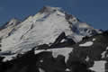 We hiked the trail out to Artist’s Point, an easy walk, but a dramatic one with Mount Shuksan to one side of us and Mount Baker’s glaciers towering over the other. Around us were snowfields and snowmelt ponds amongst the rocks. Down below were waterfalls, lakes, and creeks, some buried deep in beds of volcanic ash. Everywhere we looked was evidence of thousands of years of eruptions and lava flows, though the mountain’s been quiet for the last thirty years. Summer at this elevation is squeezed into a few weeks in August and September, so all the plants were in flower.
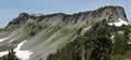 It was so beautiful up there that we looked for another hike, and chose Table Mountain, which we’d seen on our walk as a wall of softish grey rock. In the picture, the trail goes up the rightmost end of the mountain. At the top of the first snowfield was a sign forbidding dogs and small children, which Sandie found to be worrying. Then we met a couple coming down, who warned us to leave our trekking poles behind: “You’ll need both hands for the climb.” That was enough for Sandie, who decided to sit this one out as soon as the trail became steep. The top of the trail was very steep and narrow, with a long drop-off on one side, but the main danger was of sliding on the loose gravel and going off the edge. I was very glad I still had my pole, and I never had to grab the rock with either hand, so I can only conclude that the couple went up on their hands and knees! The mountain top had lots of views of the surrounding mountains and snowfields, and I thought I could see Mount Rainier, 130 miles away.
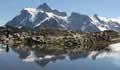
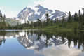 We stopped on our drive down at Picture Lake to catch Mount Shuksan’s reflection. Our last picture of Sandie’s Dad was taken here in 1988, along with Michael and Joanna.
Further down, we had enough light left to look for a campsite and I drove up the old logging road to Hannegan Pass, hoping to find a 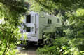 camping spot part way and hoping even more fervently that we didn’t meet anything large as we filled the road. As it happened, the only good site was at the far end of the road, a spot we’d used back in’08. It was overgrown and very tight but hidden at the back were a fire pit and a picnic table. There were lots of cars parked on the road but the people were all on backpacking trips, camping in tents, miles away, so we had the place to ourselves. We cooked our brats in the remnants of a sunny evening.
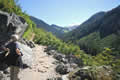 Next day, we took the opportunity to hike up to Hannegan Pass as the whole trail is only open for a few weeks. Back in ’08 I’d had to give up when I reached the snowline. This time there was no snow on the trail but we were hiking up the valley towards a notch to the left of this distant snowfield, the source of the North Fork of the Nooksak. In ‘08 the river had been flowing under the snow but now it was sparkling in the sunshine and most of the snow on its banks looked like it had fallen from the upper slopes. Our trail was a steady uphill straight line, sometimes gloomy and cool in forests of towering western hemlock and sometimes sun-blasted as we made our way across avalanche
 ![]() chutes choked by a head-high green salad. There were elderberries, cow parsnip, false hellebore, devils club, and stuff we didn’t recognize. We had butterflies and bees around our heads and patches of flowers at our feet, the usual crowd of paintbrush, lupines, arnica, and monkey flowers.
chutes choked by a head-high green salad. There were elderberries, cow parsnip, false hellebore, devils club, and stuff we didn’t recognize. We had butterflies and bees around our heads and patches of flowers at our feet, the usual crowd of paintbrush, lupines, arnica, and monkey flowers.
The trail stepped up with a switchback and became steeper and more difficult. Sandie was feeling light-headed by the 3½ mile mark and decided to sit by a stream while I finished the hike. This turned out to be wise; there was only a half mile to go but it was all switchbacks, mostly open with great views and plentiful flowers but very steep in places.
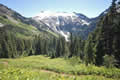 The pass was something of an anticlimax; the spectacular views like this one were behind me. The other side is a gentle descent through meadows towards distant mountains and rivers. If I’d kept walking for a day I’d have reached the Chilliwack River and followed it back into Canada where it flows into Chilliwack Lake. To the west of the pass I could see the climb up to Hannegan Peak, but that would have to wait for another day. Coming back down was rather slow as Sandie’s knee didn’t like coming down 2000 feet and we made it back to the camper just before dark.
Next morning we drove back down the road, being lucky to only meet traffic at convenient spots. We had a close call with an owl, a barred owl I think, but we all survived. We went looking along another logging road for some campsites I vaguely remembered from our previous trip. We found them and they were as good as I remembered, right on the bank of the lower reaches of the same river and with gravel beaches. We didn’t need them this time, so we just had lunch there and took GPS readings for next time. Their attraction is their low altitude, probably snow-free most of the year, a good spot to camp if we go shopping in the USA again.
On our way back into Canada I asked the border guard if it would be OK to pick up the firewood we’d had to dump. It was, but someone had tidied up and it had gone.