2010/10 Australia trip - Bloomfield Track |
|||
 We were off south again, with a couple of side trips, one along a heavily eroded track to Trevethan
  Falls. The falls was picture postcard perfect, but difficult to see, surrounded by large slippery boulders, covered in algae. I climbed through some of these and was about to step down onto a large flat algae-covered boulder when I spotted a frog swimming; it was a large, algae-covered pool! Not life threatening, but it would have been the end of my cameras.
 The other was a brief walk up towards Black Mountain, an immense pile of shattered granite boulders, covered in black lichen. The climb looked to be tough and extremely hot and I met two exhausted Americans who’d just climbed back down. One was in a lot of pain from falling into a bush. From his description, it was probably a stinging tree, but I couldn’t help him with an antidote.
Our easiest route south would have been the blacktop Mulligan Highway through Lakeland and Mareeba to Cairns, but  we’d already done some of that on the way out, so we chose the Bloomfield Track, a more interesting coastal 4wd route towards the Daintree River.
| Bloomfield Track (6.49) |
 |
|---|
The first place we came to was the quirky Lions Den pub, which seemed to have a bit of everything, food, drink, camping, stuffed lion… The location name came from a miner named Daniel.
The road became much rougher when we passed through Cedar Bay national park, a protected area but without any tracks or visitor facilities, and then it improved for the pretty village of Ayton, nestled in the rainforest.
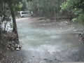
T he road followed the wide Bloomfield River up to the causeway in the aborigine town of Wujal Wujal, which looked like it would have been a real challenge if the river had been a couple of feet higher. We skipped the Bloomfield Falls, reputably an impressive sight, as we’d seen warnings about yet more alcohol restrictions and the need to hire an aboriginal guide.
Next