2005/08 Alaska and Back Again - Faro and Ross River |
|||||
Thursday August 4th
The day started with fine rain, but the clouds were high and we had good visibility for the scenery. Like last year 
 we drove down onto the Pelly River for Sandie to collect agates from the gravel bars. The water level was a little higher but it was otherwise much the same. We could still hear the great splashes from fish jumping, but couldn’t get close enough to see them properly.
Once we thought Sandie had enough rocks, we moved for a look at the town of Faro, further down the side road and across the river. The major attraction there is one of the giant dump trucks that used to carry ore from the lead and zinc mine. The town itself was probably never pretty with its 1960-style town houses, but now that the mine has closed, it looks dismal with empty houses and boarded-up businesses. 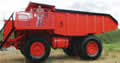 There are a few bright spots with the flowers surrounding the visitor’s centre, but I feel they are losing the battle and there will never be enough visitors to such an isolated spot.
| Robert Johnson Highways (Faro, Ross River, Frances Lake) |
|---|
Past the turnoff to Faro, the highway gets a lot narrower, and it had been wetted by tankers ready for grading the gravel. We were promptly covered in mud from bottom to top.
 Faro was too far from our destination for a single tank of gas, so we had to fill up a bit further on at Ross River, on another side road, the Canol Road. The Canol was built during WW2 to connect Whitehorse and the Alaska Highway with the oil wells at Norman Wells in the North West Territory. The war ended before the road was put to use, but the southerly section is still maintained to Ross River, with the northern section still accessible via the Ross River ferry on a “at your own risk” basis. Tempting but something we would have to leave for a future trip.
Ross River is an interesting place. It’s an Indian town, with large, government buildings and a sad collection of private houses and failed businesses. The main road into town is concrete with street lighting, but all the side roads are poor gravel. The only thriving business seems to be the general store which is also the only operating gas station. It’s a one-man store, so everything in town stops for lunch.
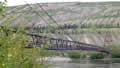 The town’s features include a 1943 truck at its entrance, a remnant of the WW2 construction force, the Pelly Barge
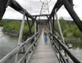 (Canol Road ferry), and the footbridge over the Pelly and Ross rivers. The bridge dates back to when the road was being built, and crossing it is like going to the crazy house at the fair, as it has every angle except square, and more nails missing than in. John and Edna and I walked across it, and Edna was not a happy walker, particularly when it began swaying for some reason.
From that point onwards the highway became little more than a dusty track, not much wider than the trailer. It was pitching around in all directions on the bumpy road, but I could only feel it, not see it, as the trailer had disappeared into the dust cloud. Major roads in the Yukon are treated with calcium chloride to reduce dust, but obviously not this one! When we stopped we found that the inside of the trailer was covered with dust. We could sweep up the floor but of course it also covered seats, beds, towels, and clothes. This is probably what the Alaska Highway was like back in the 50s and 60s before it was improved.
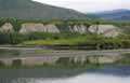
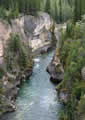
In return for all this dust we had two hundred miles of unspoiled wilderness: mountains, lakes, and rivers, and no towns or buildings. We surprised one large grizzly, which bounded off the road and into the woods before we could grab a camera. We pulled into a campground at Frances Lake. We had a view of the lake, but the area was really too buggy to enjoy it.
Next