2005/08 Alaska and Back Again - Klondike Highway |
|||||
Wednesday August 3rd
As the truck and trailer had made it down from the Top of the World to the Yukon River valley OK, we assumed that the problem with the wheel had just been overheated brakes, and we decided to continue and hope for the best. [We later found that the noise came from the “wear-out markers” going up in smoke. We had worn the brakes out in two months!]
| Klondike Highway (Pelly Crossing) |
|---|
Although we were now back in Canada, we were still about 2000 miles north of Chilliwack with about ten days left. This would leave us a little time for some side trips. We set off south down the Klondike Highway towards Whitehorse where we’d been about three weeks earlier. Sandie and I had driven this highway last year after our trip to Inuvik but then we had been surrounded by fires and had seen very little through the smoke other than the road. This time we began with a bright sunny day. The road follows the Tintina Trench, a great fault line that runs across the Yukon, responsible for some big earthquakes in the past, but also the reason why this is a productive mining area.
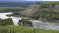 By the time we reached Stewart Crossing, clouds and light rain had arrived and stayed with us past Pelly Crossing. As you might guess, these are little places that once grew up around the ferry crossings of their rivers. Today the ferries are gone and there is just a bridge and a gas station. The scenery gets more interesting further on where the road follows the Yukon River for a way. There’s an overlook for Five Fingers Rapids, which was a dreadful place for the Klondikers floating down on their rafts. Great rocks split the river into five fingers of rapids and many rafts and people were lost there. Steamboat operators later dynamited some of the rocks out of the way, but the rapids are still impressive.
Just north of Carmacks I spotted the area where Sandie had found a seam of opalized agate last year so we stopped there for a few minutes to chisel out some more bits for Sandie’s collection. Carmacks is stuated at the Klondike Highway’s junction with the Robert Campbell Highway, and we had to decide whether to stay on the Klondike to Whitehorse and retrace our route back down the Alaska Highway. The alternative was the Robert Johnson Highway, 400 miles of secondary road with no towns or buildings, through some of the wildest country in the Yukon. The weather looked to be clearing, so we decided that the chances of seeing wildlife and great scenery outweighed the risks of driving that highway.
That evening it looked like a good choice: the scenery was gorgeous, with the Yukon River, ancient mountains, and lakes, all lit by the evening sun. The road was better than expected, a mix of blacktop and gravel, and no serious potholes. Wildlife sightings were limited to a cow moose and numerous suicidal squirrels. We put in a further 100 miles before reaching the Johnson Lake campground on the side road to Faro. John and I cooked bratwurst and hamburgers over the fire and personally fed the local mozzies.