2004/08 Yukon trip - The road home - |
|||||
We set off from Dawson Creek on the 700 mile trip south to Vancouver via Chetwynd and Prince George. However, we’d driven this road before, back at Expo ’86, so this time we did a detour via the Tumbler Ridge loop instead.
| Cariboo Highway (Monkman Park, Chasm) and Sea to Sky Highway (Lillooet, Duffey Lake, Horseshoe Bay) |
|---|
Sandie pointed out that we were now into about 300 miles of accumulated detour. Tumbler Ridge was a real surprise, a planned town, rather like finding England’s Crawley or Bracknell in the midst of the wilderness. It was built in the 1980s for the workers at the new Quintette coal mine. The mine closed in 2000, so now it seems to be a dying new town. There’s obviously some work still in the gas and oil industries and in tourism, but not enough to fill the houses and sustain all the shops and restaurants.
We headed past the Quintette Mine, a great ugly installation, even uglier as it’s not being used. A maintenance crew still works there as it may reopen if the price of coal goes up enough. The road was probably widened and 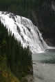 improved in the 80s but it is now pocked with bomb craters and especially bad where it has to go though a series of tunnels under the banks of coal. We were on our way to Monkman Provincial Park, which is mainly noted for Kinuseo Falls, a massive waterfall where the Murray River plummets 200 feet over a cliff. There are a number of spots for viewing the falls, and we spent a pleasant afternoon hiking and climbing on the trails around the river. The rain had stopped and we had an hour or two of sunshine.
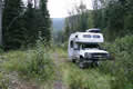
We camped down a disused logging track that led off from the park road. It was heavily overgrown but the camper makes a great weed whacker. It promised to be a very quiet spot, as most cars couldn’t negotiate the ditches across the road. When the logging companies decommission a road they remove the drainage culverts that run under the road, resulting in some unfriendly ditches to cross.
Sunday 22nd August
 We weed whacked our way out again on a very wet morning and returned to Tumbler Ridge for gas and water. We learned that the weather forecast was for snow that evening, so Sandie was for
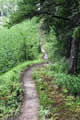
 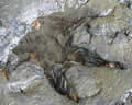 heading south quickly. However, I had also learned that there were dinosaur footprints up on Flatbed Creek, and I just had to take a look. Sandie was still feeling the effects of the cold, and is never very keen to hike in the rain, so she didn’t go. It was a much longer hike than the map suggested, with lots of steep ups and downs, but, sure enough, there is a bed of sandstone on the creek’s edge that has therapod footprints that just jump out at you. They’re now unmistakable, but nobody ever went there until some kids in a canoe discovered them. There were supposed to be prints from other types of dinosaur such as the ankylosaurus in the bed too, but they were less obvious in the driving rain. These therapods were not giant dinosaurs. My guess is that they took a size 9 sandal, and were perhaps a little smaller than the velociraptors in Jurassic Park.