2004/08 Yukon trip - The road home - |
|||||
Muncho Provincial Park was our next stop. The smoke had cleared a bit, only to be replaced by rain and clouds.  Muncho is famous for its blue lake and blue rivers, but the weather kept us from seeing much of the colour. I did manage to hike around the cliffs to see the hoodoos. These are pinnacles of volcanic ash, soft enough that they look different every year. The surrounding peaks are the most northerly part of the Rocky Mountains, and they were spectacular, even in the rain.
![]()
We camped for the night on the edge of the Racing River, yet another of those icy-cold beautiful turquoise blue rivers. It deserves its name, hurtling downhill under the highway bridge. It’s one of those rivers that you feel nervous beside as falling in would be almost certainly fatal.
It was our first cold night in a while and I cooked up a powerful Thai curry for the occasion. Amazingly, the little general store back in Dawson City had stocked curry paste and coconut milk.
Friday 20th August
We awoke to an even wetter day. The road passed though Stone Mountain Provincial Park, which is noted for its stone sheep. We didn’t see these or the mountain as we had thick wet fog for most of the trip. This was a really 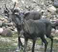 scary drive, as we couldn’t see much of the road or the cliffs on either side of it, but just enough to know that mistakes could be very serious. We did see a few caribou who ventured close to the road. These guys were woodland caribou and they seemed to be significantly larger that the barren-ground caribou who migrate across the Yukon. All that migration must wear their legs down. We stopped for lunch at Tetsa River provincial park, a scenic spot, but it was still raining.
Fort Nelson is the only place of any size on the highway. All the others are just roadhouses. We stopped at Fort Nelson for a little shopping and also at the library to access the Internet. This is where we learned that Hans Mikkelsen had died from colitis. Hans was a member of my architecture team at Unisys and he was also captain of the softball team I used to play for. Peg, his wife, also worked for Unisys, and she was manager of the softball team. As always, it’s tough to accept that someone younger than you can die so quickly. I’m glad that I stopped by to see him the day before we came on this trip. As usual, he gave me an update on all the code he’d put into the system, the problems that he’d had and the fixes that had to go in. As he did about three times as much effective work as most people, these problems were insignificant, but Hans was always like that. When I retired he had picked up a lot of the work I used to do, so Unisys has to be hurting right now. We’d already heard back in Inuvik that Bob Krieger had died from a brain tumour. I worked with Bob for a while down in Clear Lake, Iowa. When Unisys dropped the Clear Lake products, he formed the TeamQuest company to continue providing them to Unisys customers. Despite some really tough competition, the company had prospered for thirteen years with Bob as CEO. I last talked with him at last year’s customer conference in Reno. Hans and Bob were great characters and they’ll be sorely missed by their families and by us.
The road south from Fort Nelson is not very exciting, mainly a wide cut through the forest, with little to see other than a billion spruce trees. So, although it was raining with low cloud and fog, we weren’t missing much. We started looking for a campsite, but all the side roads we looked at had Keep Out signs or “Dangerous Hydrogen Sulphide” warnings. I guess this is BC’s gas and oil zone, and the recreation sites we were looking for are now off limits to the public. We finally found a very muddy spot on a Canfor road, just off the highway. It had more traffic than we expected and a couple of trucks stopped to look us over, but nobody told us to move on.
Saturday 21st August
We had camped just south of Pink Mountain, a mountain that is so covered with fireweed that it glows pink in the summer. However, we couldn’t see the mountain, let alone the pink! The weather stayed dark and gloomy but mainly dry as we drove past Fort St John and Taylor to Dawson Creek and the southern end of the Alaska Highway. Sandie wanted to take the short cut to Chetwynd via Hudsons Hope, but we’d already driven that road in the past and I was hoping that there’d be some scenic spots aroud Taylor, where the road crosses the Peace River. Sandie’s plan would have been better as the scenery (and smell) at Taylor is marred by a large oil and gas refinery. Further along the road the entrance to Dawson Creek has a street full of grain elevators – truly the entry to the prairies. The grain elevators are there to service the Peace River and Grande Prairie wheatfields, great 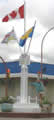 agriculture but boring scenery.
We took some photos at Mile 0 of the Alaska Highway. The milepost is located in the middle of an intersection, guaranteeing a dangerous experience for anyone posing with the post. That’s why Sandie isn’t in the picture.