2019/11 Australia trip - White Cliffs |
|||||
Thursday November 14th
We were getting close to our target, Broken Hill, but thought we should check out some of the local national parks and scenery. The plan was to drive through Pardo-Darling national park to an opal-mining area called White Cliffs and then return through Mutawintji national park, another area with aborigine art. But the challenge was to find the right road. John had spotted a dirt road going off in the right direction, but after trying it for a while we realized that we were on the wrong side of the river and there was unlikely to be another bridge anywhere close. So we went back into town and tried again.
The next road had a sign that pointed to Wanaaring with a hint that a left turn somewhere would take us to White Cliffs, about 60 miles away, but it didn’t say how far to the turn. Our maps were vague and the GPS didn’t think any of these tracks were roads, so we were winging it.
The road was mostly quite good and wide except where it crossed cattle grids and streams. The streams had obviously cut the road in the last rain and it hadn’t been graded since. We’d all driven roads like this all over Australia but it had mostly been in the Troopy 4wd camper, carrying at least a week’s worth of food and water as well as a winch, sand mat, tools and parts, and sometimes a satellite phone. The Outlander had 4wd but apart from that we were pushing our luck!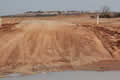
However, we made it OK and the picture shows the last crossing before the White Cliffs which are just visible in the distance. Edna felt a bit battered; her back is sensitive to the bumps. We’d passed through a part of the Pardo-Darling park but it had looked no different from the rest of the drive. It was probably a case of the park service protecting a type of environment rather than an area of outstanding natural beauty.
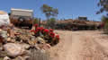
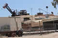
White Cliffs turned out much as expected, a smaller version of the more famous Coober Pedy and Lightning Ridge opal capitals. There were places to dig for opals, and underground mines, houses, a motel, and restaurants. Unfortunately, most places seemed to be closed, and we ended up eating at the café behind the service station, as lovely as it sounds.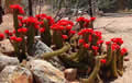
These cactus flowers provided a rare speck of beauty; the big picture isn’t as pretty: a derelict caravan, broken machinery, shacks, and rocks, piles of rocks everywhere.
 We drove up to the top of one of the mounds, above the white cliffs. The view emphasized how isolated the spot is; nothing but near-desert to be seen.
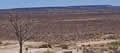
We gave up on Mutawintji as it involved a long drive on dirt roads, probably as bumpy as what we’d driven that morning. Instead we took the alternative bitumen road almost back to Wilcannia and rejoined the Barrier Highway. (Bitumen is the Australian name for what the English call tarmac and the Americans call blacktop.)
We were about halfway through our four week vacation, so this is a convenient place to end Part 1 of our journal. Part 2 will cover our stay in Broken Hill and our return to Melbourne and our second trip to the Grampians and the Great Ocean Road.