2019/04 Panama trip - San Lorenzo Forest |
|||||
 Thursday April 25th
Our alarm went off at 5 am, a 30 minute lie-in. These hours made sense; we were in the tropics, with twelve hours of daylight year-round. Everyone wanted to be out and looking for birds from 6.30 am to 6.30pm.![]()
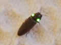
This bug was on Sandie’s bed in the morning. Not surprisingly it’s known as a headlight beetle.
We were going to be off on a day-long trip to the San Lorenzo Forest on the Caribbean side of the country. It turned out that we were the only people signed up for the Mammals and Birds tour, so although we’d be in a group of 8 for the Bird trips, we’d be on our own for the Mammal trips, essentially a private tour. Quite a few of our fellow guests were intrigued by our itinerary, particularly those that wanted to see more than birds. Our tour had been the last on Canopy’s list with details on a separate web page so they hadn’t noticed it.
We were traveling inside the pickup this time. Igua took us back to the four lane tollway and turned north towards Colon. Because of the isthmus’ orientation, the Panama Canal goes north-south, from Colon on the Caribbean side to Panama City on the Pacific. Igua told us that the tollway is new; the trip used to take hours rather than minutes.
Colon is named for Christopher Columbus, who visited the coast on his fourth voyage. Today it has a reputation for crime, but we only touched on the outskirts, which looked to be a mix of shacks and ugly concrete buildings. Most of the traffic appeared to be American school buses, some painted in the liveries of local bus companies. We were surprised to see a Sobey’s supermercado, presumably a Canadian enterprise.
 San Lorenzo is on the other side of the canal from Colon. When the canal was built a hundred years ago there were no bridges so it cut the country in half and traffic had to either use a ferry or drive across the locks when they were empty. A
 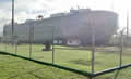 hundred years on there are two bridges at the Panama City end, carrying the Pan-American Highway, but we were about a month too early for the opening of the new bridge at the Colon end.
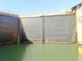
Instead we drove to the Gatun Locks, where we drove across the bottoms of the locks with waiting freighters towering over us. The locks are drained for a few hours in the morning to allow road traffic through, but we’d have to come back by ferry. The picture shows one of the lock gates holding back the waters of Lake Gatun.
| Gatun Locks (6.01) |
 |
|---|
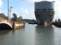
![]() We stopped to look out over the lake and Igua explained how the canal works.
We stopped to look out over the lake and Igua explained how the canal works. 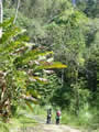 Lake Gatun was created by damming the Chagres River and the lake is the heart of the canal. Ships coming in from the Caribbean are elevated by three successive locks up to Lake Gatun’s 84 feet. They then follow a dredged channel across the lake to the Pedro Miguel lock where they drop to Lake Miraflores and to the Miraflores Locks where they drop again to the Pacific Ocean. Every time a ship drops down to the ocean, millions of gallons of fresh water are lost so it is fortunate that the area is a rain forest with prodigious rainfall.
![]()
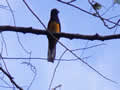
There was little traffic on the other side of the canal and we drove to a quiet dirt road leading into the jungle. There were plentiful birds; trogons, manikins, and hummingbirds, as well as orchids, air plants, and large showy 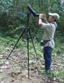 bromeliads. There didn’t seem to be any mammals but we didn’t care; we were enjoying the trip anyway.
![]()
| Sensitive plant (0.25) |
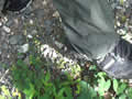 |
|---|
| San Lorenzo birds (0.37) |
 |
|---|
The two pictures show a “sensitive plant”, a kind of mimosa, before and after touching. The stems are still there but the leaves shrivel to nothing when touched; if left alone they reappear after a few minutes.