2018/07 Arctic Part 3 - Peta Lake |
|||||
 At Kitwanga Junction we headed east on Highway 16, the Yellowhead Highway, also known more sadly as the Highway of Tears. There is no
  public transport in the area so the poor have to hitchhike and over a dozen women, mainly native, have gone missing, with some found murdered.
I had found a couple of campsites on our map of the Suskwa Forest Service area. The first was almost ideal, a flat area on a beach of the Bulkley River. The snag was the three foot hop down onto the beach; I was doubtful of our ability to hop back up without building a ramp.
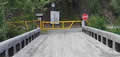
The other was on the Suskwa River about five miles down a little used logging road. We made it to the river but found there was a brand new locked gate on the other side of the bridge. We had stumbled into a dispute between the chiefs and the local people of the Gitxsan nation, who are objecting to the multi-million dollar deal their chiefs made to allow a Liquefied Natural Gas pipeline across their land.
We had no choice but to back up and camp in a nearby log loading area where we could hear the river even if we couldn’t see it. It was a pleasantly warm evening.
 Monday July 16th
We had a very quiet night with the road blocked and didn’t see any traffic on our way out. We’ve often seen bears on this section of the 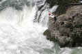 Yellowhead and this morning was no exception with two roadside bears.
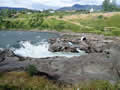
We stopped at Moricetown where the Bulkley River plunges into a canyon and members of the Moricetown band net the salmon and steelhead trying to make their way up the waterfall. It was good to see that they now have helmets and safety 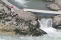 lines; it’s a dangerous job.
It looked like this was a scientific survey, measuring and weighing. Later in the season there’s a very efficient production line, from net to knife in seconds.
| Moricetown (10.29) |
 |
|---|
We stopped in Smithers for diesel and propane and then moved on for lunch at nearby Driftwood Canyon. Along the way we had this view of Hudson Bay 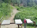 Mountain and its glacier. We once camped at the base of the cliff where those cascades converge. Noisy and damp!
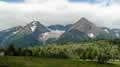
At Driftwood Canyon, a short trail leads to a cliff face of fossils, mainly leaves and stems but occasionally fish and birds. No collection is allowed but it’s hard for visitors to understand this as all the new and fancy signs in the canyon are large and high and reflect daylight, making them unreadable even on a cloudy day.
 Our rockhounding book told us of a Burns Lake logging road, the Augier, which led to a rich bed of agates. We followed directions for over thirty miles into the logging road network only to find that the Augier road was blocked by a waist-high berm. The picture doesn’t show the height of the berm very well but the camper couldn’t have crossed it. The Jeep crowd had already cut a path over the end of the berm so Sandie drove the camper like a Jeep and followed the path.
But then we found that the road’s culverts had been ripped out leaving transverse ditches. We dumped in tree trunks and branches to cross those. It was all to no avail as we came to an uncrossable ditch in front of a missing creek bridge. This was long before we were supposed to reach the agate bed. Our truck doesn’t have the Evel Knievel package so we had to give up. There were no agates where we were but there were great clouds of tiny biting flies; not a good place to camp.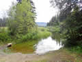
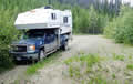
We had no luck finding another route to the agates. While we were trying to make sense of the maps yet another bear trotted past. We got lost on our exit, finding ourselves in a different logging network. By pure luck we found this camping spot at Peta Lake, perfect for canoes and kayaks, but we’d packed no boats on this trip.