2018/07 Arctic Part 3 - Stewart |
|||||
 Back on the Cassiar, we came to Jade City, one of the few “places” on the highway. The city used to contain two shops, one on each side of the highway, but the shop on the eastern side looked to be closed.
The survivor is a large outdoor mining museum as well as a shop. It sells carvings made from the nephrite jade and rhodonite mined locally by the family. Sandie already has a collection of similar carvings so we just enjoyed the museum and didn’t buy.
We came to Dease Lake, the biggest place on the highway. Most of the town is actually off the highway so all that travelers see is the service station. As there are few places to fill up, everyone stops there. On this afternoon there was one cashier trying to handle a dozen or more customers. And one idiot customer who had to wash all his windows twice while blocking half the pumps. We were happy to leave before warfare broke out.
Dease Lake is also the junction for the very interesting road that leads through the Tahltan reserve to the Stikine River Canyon and the very remote village of Telegraph Creek. We drove that road back in 2004 and regard that trip as an adventure. We didn’t repeat it this time. Sadly, many of Telegraph Creek’s buildings burned a month later in a forest fire.
![]() The highway winds through a succession of mountains, some of them volcanoes: the Cassiar, Stikine, and Skeena ranges, and Mount Edziza.
The highway winds through a succession of mountains, some of them volcanoes: the Cassiar, Stikine, and Skeena ranges, and Mount Edziza.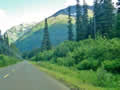 There are some wonderful places in those ranges but no roads, so they are only accessible via multi-day treks or floatplanes. But we enjoyed our views of the mountains and lakes we could reach.
Somewhere we’d acquired a yellow line on the highway and we concluded that we must be approaching civilization.
We were looking for a place to camp; there were plenty of logging roads but they quickly climbed into the mountains without any flat spots. We usually try to find a logging “main”, as these are relatively easy to drive, with conveniently flat loading areas. However, I think the Cassiar was built by linking up those logging mains, which is why those steep roads come down directly onto what is now the highway. 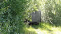
We settled for an overgrown track heading into the forest, probably to someone’s cabin. It hadn’t been driven in months so we gambled the 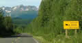 owner wouldn’t show up. He didn’t.
Saturday July 14th
We had a warm and sunny morning, rare on this trip. We continued south on the Cassiar, and soon came to this warning signs for bears.
We have a similar sign on our front lawn, but it’s rare to see them on the highway. Warnings for caribou or moose or deer or elk are common but not for bears. However, the sign was correct and I think we saw a half dozen black bears at the roadside over the next two days.
| Distant bear (0.05) |
 |
|---|
The road’s full name is the Stewart-Cassiar Highway, and Stewart was where we were headed, passing the turning towards Kitwanga Junction and the Yellowhead. This section is also called the Glacier Highway and it climbs steeply through the Skeena Mountains, visible behind the sign. It’s an apt name for the 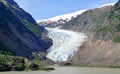 highway as the mountains tower over the road and many are topped with hanging glaciers.
The Bear Glacier flows down to road level. It’s still impressive, but it looked to be only about a third of its size in 2004. Back then the glacier extended into the lake and boasted a cave big enough to kayak into (if I’d been allowed!) Now it barely (or bearly) reaches the lake.
This ice cone was probably formed under a dripping snowfield which had since melted away, only to reform this coming winter and drip to oblivion next spring.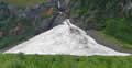
We followed the Bear River down from the pass, surrounded by waterfalls threading down the cliffs. On a wet day, there are many more of them and they are bigger and noisier, but we happily settled for sunshine.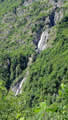
The cliffs are sheer, presumably cut by some gargantuan ancestor of the Bear Glacier. At the bottom of the hill is Stewart, Canada’s most northerly ice-free port. Stewart is at the head of the Portland Canal, a 70 mile-long natural channel to the Pacific Ocean. The town is on the flat estuary of the Bear River, hemmed in by mountains and cliffs.