2018/07 Arctic Part 2 - Ross River |
|||||
 We returned to the highway, which continued as a gravel road, with blacktop on some of the hills. We’d heard on the radio that the Watson Lake end of the Robert Campbell Highway might close because of a forest fire, but that wasn’t a worry as we were planning on leaving it partway and going south on the Canol Road.
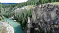
We stopped for coffee at the Lapie Canyon, a scenic spot, though its beaches were inaccessible from the road.
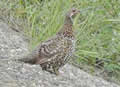 Shortly afterwards we met this blue grouse. All grouse seem to have the same defensive technique; they freeze, hoping to become invisible. This may work with coyotes and wolves but it’s ineffective with trucks and cars. If you manage to stop without squashing them they will very slowly take one step on the road, then another, and another until they reach the cover of the undergrowth where they break into a gallop.
We took the Canol Road turning down towards the community of Ross River. We were only there to take a look around; we’d be coming back out to take the Canol Road south to the Alaska Highway.
| Grouse (0.09) |
 |
|---|
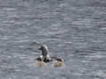
On our way down the hill we spotted this family of red-throated loons, not as tuneful as their common loon cousins, but quite pretty birds. This one seemed to be 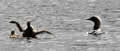 saying “Look at me, Mom!”
| Loons (0.18) |
 |
|---|
Ross River is a Dena Nation community of a few hundred people. Surprisingly, its entry road with its soaring concrete light pylons looks like 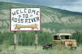 the approach to a major city. Incongruously there are the remains of a 1940s truck at the side of the road. It’s presumably there as a historic statement but to the uninformed it just looks like old junk.
It is the only community on the Canol Road, which was built by the Americans in 1944 to bring oil from up north at Norman Wells in the NWT, down over 300 miles south to the Alaska Highway. At the end of the war it was abandoned, including the hundreds of trucks and bulldozers used to build it. Today the Yukon government maintains its end of the road, largely for prospecting.
![]() A cable ferry across the Pelly River connects the North and South Canol Roads. From the size of this truck coming off the ferry, we’d guess
A cable ferry across the Pelly River connects the North and South Canol Roads. From the size of this truck coming off the ferry, we’d guess 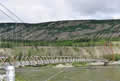 that the North road had been upgraded since our last visit.
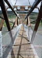 The ferry cannot run during fall freeze-up and spring break-up so there is also a footbridge. This one is brand-new, with steel gusseting and massive concrete anchors. It replaces the one we last used in 2005. The old footbridge had popped nails, missing boards, and a spiral warp; it felt like the Crazy House at the funfair. This new one is much safer but lacks character.
A storm rolled through while we were exploring and we had to dash for cover.