2018/07 Arctic Part 2 - Dawson City |
|||||
![]() We had a very scenic drive through the Ogilvie Mountains, great piles of rock fragments, with no sign of strata. Nothing tall was growing on
We had a very scenic drive through the Ogilvie Mountains, great piles of rock fragments, with no sign of strata. Nothing tall was growing on 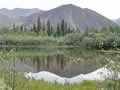 their north slopes, only grass and lichen on the others, but in places the rock’s colours would shine through. This is a landscape like no other.
![]() We reached the limits of Tombstone Park and the mountains became more jagged. We had a better view this time of the magnificent North Klondike River valley with Tombstone Mountain at its head.
We reached the limits of Tombstone Park and the mountains became more jagged. We had a better view this time of the magnificent North Klondike River valley with Tombstone Mountain at its head.
Further on was the interpretive centre, new since our last visit. The exhibits, the stories of the geology and animal life, were well done. We were chatting with the 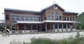 rangers about pelicans and cranes.
After an hour or so of driving we reached the end of the Dempster Highway, crossed the Klondike River, and headed west into Dawson City. 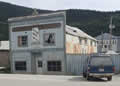 Dawson was the centre of the Klondike Gold Rush in the 1890s. Today its main business is tourism, but there are still gold mining companies pulverizing the Klondike’s hills with water jets in what is called placer mining. The town is an odd mixture of preserved old buildings like its saloons and the opera house, abandoned ruins, and brand new town houses built to match their surroundings. The Flora Dora Hotel was perhaps the closest to reality; a careworn fascia fronting a decrepit building.
The streets were in the midst of reconstruction and getting around town was difficult, tough for the local businesses as their season is so short. We found the Internet and this grocery store. We had a long search for the non-existent entrance to the 1900s Yukon liquor store and when we found the 2018 store the sign said “closed on Mondays”. 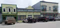
These were some of our pictures from around town. 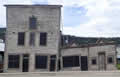 These leaning buildings show what happens if you build directly on top of permafrost, and heat the building and melt the ground beneath. Eventually people learned to build on wood piles and later on steel piles when they found the wooden ones rotted after fifty years or so.
T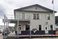 his is the Bank of British North America as it was a century ago; it eventually merged with the Bank of Montreal.
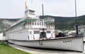
The SS Keno sternwheeler, now in dry dock, was built to carry silver and lead ore from the mines in Mayo down the Stewart River.
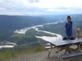
 We drove the steep road up to the Midnight Dome, high above Dawson City. It was originally named in the belief that at midnight on the
 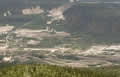 summer solstice the sun would not set, even up there with a view of the horizon. A bunch of people climbed the dome to watch this and, as Dawson’s well south of the Arctic Circle, they were disappointed. But a tradition was born and a tourist attraction created. It is a spectacular view, worth the climb.
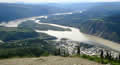
The view is dominated by the Yukon River, centre, with the Klondike flowing in from the left. To the right are the southern streets of Dawson City. Out of sight on the right is the Yukon ferry which leads to the Top of the World Highway and Chicken, Alaska.
In this close-up of the Klondike Valley, the bottom shows the worm casts left by the gold dredges, a practice abandoned over 50 years ago, and the top shows the scars left by placer mining (water cannon), a practice still in use today.
| Yukon River (0.21) |
 |
|---|
 Down in town, I parked carefully.
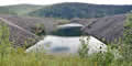
At ground level we could see some of the effects of dredging, great berms of rocks alternating with ponds of water, no use for anything.