2018/07 Arctic Part 2 - Arctic travel |
|||||
Saturday July 7th
We left Inuvik in a fine drizzle, heading south on the Dempster, greasy from the rain but good, firm gravel. It was buggy at the campground and it stayed that way for our first few stops.
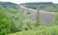
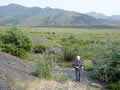
![]() We stopped at the Tithegeh Chii Vitaii Lookout, which I remembered had a good view over Campbell Lake. There was a new, groomed trail, which led us a long way down into a swampy area with clouds of bugs. Sandie gave up and retreated while I found the old trail which was steep but direct and short with few bugs. I imagine that some bureaucrat decided that the old trail didn’t meet safety standards so directed that another “easy” one be built to replace it. The lookout was worth the short climb.
We stopped at the Tithegeh Chii Vitaii Lookout, which I remembered had a good view over Campbell Lake. There was a new, groomed trail, which led us a long way down into a swampy area with clouds of bugs. Sandie gave up and retreated while I found the old trail which was steep but direct and short with few bugs. I imagine that some bureaucrat decided that the old trail didn’t meet safety standards so directed that another “easy” one be built to replace it. The lookout was worth the short climb.
 We had coffee at a river overlook. We crossed the river on this high berm; not a good place to slide off the road!
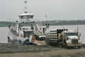
We came to the Mackenzie River ferry. We considered visiting Tsiigehtchic, the Gwich’in village that occupies the confluence of the Mackenzie and Arctic Red rivers. The ferry would take us there if we asked. I was tempted to ask and show off my pronunciation, but we’d been there in 2004. It had seemed a dour place, but on that day it was brightened by a wedding, with the bride and groom in the back of a pickup and being paraded around town. We decided to keep that as our memory of Tsiigehtchic and bypassed it this time. The ferry was well-loaded this time, with trucks and motorhomes.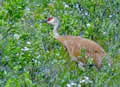
We noted that the river valley still had bulldog flies. We’d been really glad they hadn’t spread any further north. More welcome were a pair of sandhill cranes, mostly hidden in the brush, but Sandie caught this one when it emerged.
| Sandhill crane (0.12) |
 |
|---|
Further south I took a side road that I thought might lead to the quarry we camped in back in 2004 along with dozens of sandhill cranes. It was a quarry track but the wrong one. This one led to a mud wallow with lots of evidence that people had got stuck there. I gunned the truck through the wallow and made it to a steep muddy hill. We crawled up the hill and were relieved to be able to turn around in the quarry. Then it was a very careful descent: 4wd low and first gear and don’t touch the steering and let the truck follow its own track. Then gun it through the wallow and back onto the road. After that adventure I wasn’t allowed to take any other side roads.
We drove into the town of Fort McPherson, very quiet on a Saturday afternoon. Sandie wanted to visit the Tent and Canvas Company but they’re not open at weekends. She wanted to replace the Northwest Territory bag that she accidentally gave away to a friend.
We thought we’d also like to go and see the graves of the lost patrol again. This was an RCMP patrol that set out in 1910’s December darkness from Fort McPherson to Dawson City, about 300 miles in the depth of winter. The patrol got lost, turned back, and eventually starved after they ate their dogs. They were found, too late, by Corporal Dempster, who was honoured decades later by giving his name to the highway.
They are buried in Fort McPherson, but as we got closer we could see that the graveyard was full of people, most of the population perhaps, so we assumed 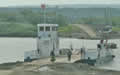 there was a big funeral in progress. They didn’t need gawping tourists around so we left them to it.
The Peel River ferry site was quiet. We thought that the ferry was coming across empty to pick us up. But it disgorged a solitary cyclist. We also had the ferry to ourselves. These ferries are free, part of the road network, and they are accommodating; they go whenever there is a load and there’s no waiting for the ferry to fill up.
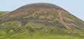 From the Peel we had a steady climb up into the Richardson Mountains, mostly bare of trees and shrubs but showing brightly coloured rocks
 ![]() and lichens on the steeper slopes.
and lichens on the steeper slopes.
T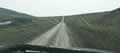 he road was being graded and a tanker was spraying calcium chloride to reduce dust when the road dries. When the road is wet though, we get covered in calcium chloride mud which sets hard when it dries out. The road gets slick too but not luckily soft.
We stopped at the Yukon border, and met a guy I’d talked to at the visitors’ centre. He said he was going home. It was reported to be raining all the way from Inuvik to Tuk and he wasn’t going to chance driving the road in those conditions. He wasn’t too happy with the current condition of the Dempster either.
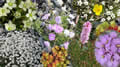
![]() We found this gem of a campsite, an old gravel pit, with folded strata, a mountain backdrop, and mounds of small flowers.
We found this gem of a campsite, an old gravel pit, with folded strata, a mountain backdrop, and mounds of small flowers. 
We had a distant view of the highway climbing into the hills.
 This was to be our last campsite north of the Arctic Circle. The weather had cleared and we celebrated by sitting outside around a fire.
Sunday July 8th
That night our solitude was disturbed by a red campervan creeping along the track and parking a few feet from us; really weird considering that there was a half mile of track they could have used. I made sure my axe was close at hand, but we never saw the occupants. The van had Belgian registration and Belgium is a very crowded country, so perhaps they didn’t feel comfortable camping on their own.
We’d planned a clean-up for the morning if it was dry and we didn’t feel obliged to be quiet, so we were out scraping the windows, chipping mud off the steps, and beating the carpets. No Belgians emerged.