2018/07 Arctic Part 1 - NWT border |
|||||
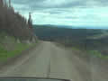
 The road north from there was very slick and slimy with black mud. We’d already noticed that it was very hard to wash off, rather like engine grease. Much of the road is elevated, with narrow or no shoulders, so meeting large trucks was a white-knuckle affair.
We came to the Arctic Circle. It is celebrated with a large parking area and signs for travelers to pose in front of. The circle is at latitude 66˚ 33’. Its only significance is that places north of the circle experience at least one day a year when the sun does not set. However, we had no sun at all at the time. The thunder and lightning was very close and the rain was coming and going. The good news was that it seemed a bit warmer on the other side of the storms.
If we’d come here in winter we might have seen thousands of caribou, as they can find lichen to eat under the area’s light snow cover, but they leave in May and go up north to the coast for calving.
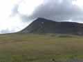
A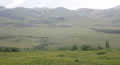 long the eastern horizon are the rounded and colourful Richardson Mountains, named after John Franklin’s surgeon; he and Franklin had surveyed nearly 2000 miles of the Arctic coast in the 1820s. Richardson was lucky enough not to be on Franklin’s later naval expedition that disappeared in the Northwest Passage, and he died at home of old age.
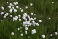
We had been seeing patches of white on the hills and assumed it was snow but as we got closer it looked like ![]() flowers, and then we realized it was the fluffy seed heads of Arctic cottongrass.
flowers, and then we realized it was the fluffy seed heads of Arctic cottongrass.
| Cottongrass (0.47) |
 |
|---|
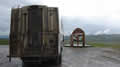
We were looking for a campsite. We couldn’t just pull off the road onto the tundra or we might sink so we had to the find a track leading to a gravel pit or similar. There were a few dead-straight side roads, all marked as private, and we thought these might be seismic lines, owned by oil companies.
The road suddenly widened and signs warned as that we were now on an emergency airstrip, so probably not a good place to camp either! The rain was heavy and the light poor when we came to the Rock River campground, so we thought we’d give it a try. It is in a sheltered valley with tall trees, protected from the wind. Just getting in was a challenge as the entrance was a sea of mud. And then we stepped out and were assaulted by clouds of mosquitoes. Sandie dived inside and tossed me the repellant. I don’t often use it but I had to go and get the forms and pay for the campsite. If I didn’t use it then I’d be bringing a few hundred mozzies back inside with me. Even so Sandie was busy with the swatter most of the evening.
Tuesday July 3rd
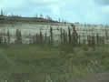
We had a lazy morning, reluctant to go out and face the bugs. But the rain stopped and it was time to be off. We never did walk to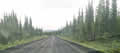 see the river. Despite the rain we were still covered in mud; that stuff was super sticky. The road seemed to be better, maybe more gravel and less mud, even though it looks greasy in this picture.
| Dempster Highway (0.42) |
 |
|---|
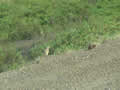
 The Richardson Mountains were looming ahead of us, mostly bare, with no trees, but reds and
 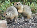 yellows in the rock strata. There were streaks of snow across their faces, not glaciers but just slow to melt at this latitude. We weretaking pictures of the mountains when we noticed these little bodies rolling around amongst the rocks. We think they are Arctic ground squirrels. I counted four of them but I never got more than two in the pictures.
| Ground squirrels (0.20) |
 |
|---|
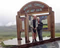
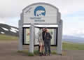 We came to the border between the Yukon and the Northwest Territory. Both territories have welcome signs, the Yukon jn English and French, the NWT in English and Gwich’in, the native people’s main language.
| NWT Border (1.05) |
 |
|---|
The time also changed to Mountain Time, even though it’s a north-south border. The NWT is administered from a thousand miles away in Yellowknife, so it’s more convenient for politicians there and in Ottawa to have one zone even though there’s no direct road connection across the NWT to Yellowknife. As a result, all travelers on the Dempster have to cope with a 1 hour time change.