2018/07 Arctic Part 1 - Tombstone Park |
|||||
Our bad news was that the camper’s battery had gone down to nothing even though very little was on. We’d bought it on our Newfoundland trip, so it was on its way out after only 2 years. Our plan had been to go directly to the Dempster Highway but now we’d likely have to go into Dawson City to buy another battery.
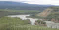 We followed the Yukon River for a while, and stopped for this view of Five Finger Rapids. This was a very dangerous point for overloaded boats and rafts making the journey from Skagway via Lake Bennet and the Yukon River to the Klondike. Eventually some of the fingers were amputated with dynamite.

We stopped at the service station in Pelly Crossing just in case they had batteries, but the cashier just pointed to the AAs behind the till. To our surprise though, outside the station was a familiar sight, a Tiger Motorhome, belonging to Don and Mickey from New Mexico. Don is a retired mechanic, and is restoring an ancient Harley when not traveling. Mickey is a rock hound and a quilter. There went about 2 hours of our day!
The roads were getting rougher, OK for us but difficult for some trailers. They’d slow to walking pace so we had to be aware that we might have to screech to a halt too.
We drove past the entrance to the Dempster; it was another 30 miles to the outskirts of Dawson City. We didn’t have high hopes as we were shopping for a battery on Canada Day and it was also a Sunday. At the first service station I tried, the assistant looked vague when I asked for a camper battery and then said do you mean one of those? She was pointing to about twenty batteries of various shapes and sizes on the floor. Perfect! I found one that matched our dead one and handed over about twice the price I’d have paid in Chilliwack.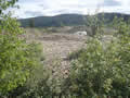
Between the two of us we managed to install it. Even without any additional charging it was already better. We found a spot to eat our much delayed curry lunch, surrounded by gigantic wormcasts. These were created decades ago by gold dredges which ate their way up and down the valley filtering out the gold and spitting out the remains.
We went back to the junction with the Dempster to fill up with diesel; it’s a long road so you want to start it full. The pumps had instructions but no credit card reader, so I went to the hut only to find it empty. Someone else came over and pointed at a single reader set into the door at about waist height. Then it was back to find out which pump I was parked at. I went back to the reader and the other person was yelling “Don’t touch it or it’ll cancel mine! Let me start my pump first.” Eventually, while I was filling up I looked up and saw the detailed instructions about 8 feet up! Of course I didn’t get a receipt or even an indication of how much I’d spent, but at least we were full, with enough in the tank to make it to Inuvik without refueling, if needs be.
We were just happy to be on the Dempster Highway after a week of driving. We took the obligatory picture in front of the sign and
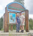 then crossed the single track bridge across the Klondike River. Inuvik was now about 450 miles of gravel road to our north.
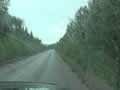
This picture show a typical section of the highway, lined with stunted black spruce, billions of them. The trees would disappear as we climbed into the high plains and then reappear as we descended into the Mackenzie River lowlands and Inuvik.![]()
| Dempster Highway (0.25) |
 |
|---|
The road was good gravel and it soon became apparent that there were three classes of travelers. Those with fragile RV gear were doing about 40 mph, truckers and workers in pickups were blasting along at 60mph or more, and people like us who had resilient gear but weren’t in a hurry doing about 50 mph. It still made sense to slow down for oncoming trucks or risk losing your windshield.
The scenery beyond the road was wilderness, with more of those short black spruce trees standing in swampy ground, and distant mountains mostly bare of trees but coloured by lichen and low shrubs. Most of the area is permafrost, with ice going down hundreds 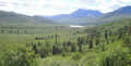 of feet and only a few feet melting in summer and supporting the stumpy trees.
We came to Tombstone Territorial Park, named after this mountain, very distinctive, though it doesn’t really look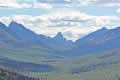 like a tombstone from the road. We noted the very stylish Interpretive Centre, new since our last visit, but now closed as it was late. We’d visit on our way back.
We remembered that Tombstone’s campground had some good trails so we were quite prepared to pay for a campsite, but all fifty sites were taken. We were surprised but probably shouldn’t have been; it was after all the Canada Day long weekend.
We stopped at the spectacular view of the valley with Tombstone Mountain at its head, but didn’t stay long as by now the day was dark, cold, and windy. We climbed up to North Fork Pass, the highest point on the highway. At 4600 feet and close to the Arctic, the pass has a grim climate and little grows there on the tundra. Tundra means “no trees”. At this altitude not enough permafrost melts to support trees or even large shrubs.
Paradoxically, this is also the beginning of an area that was ice-free during the Ice Age. The climate was too dry for glaciers to form locally and the mountain ranges formed a barrier to glaciers that formed elsewhere. The ice-free area has been termed Beringia and it stretched from the Yukon, west across Alaska and the Bering Straits to Siberia. It supported mammoths and giant bison and sloths. One theory is that the first Americans were hunters from Siberia following game across the Bering Straits, then dry land because of the low sea levels.
We bypassed a lot of the park until we found a nice gravel area with a view of lakes and mountains. We hoped to see more of the 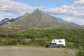 park on our way back. We were wondering if the park rangers would find us and boot us out but the park’s really too big to police, and nobody bothered us.