2016/08 Newf'land trip - Cape Breton Highlands |
|||||
![]() Dear All,
Dear All,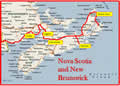
At the end of part 2 of this journal, we were on our way home from the easternmost point of our trip, Cape Spear. We had crossed the island of Newfoundland to Port aux Basques and were on the Blue Puttees ferry crossing the Cabot Strait, headed for North Sydney, Nova Scotia.
Monday August 22nd
After the wet fog of Port aux Basques we were briefly in sunshine with patches of blue sky. It’s a six hour trip and we were out of sight of land. We had a glimpse of a pod of dolphins though they might have been the small pilot whales, common on this coast. Then we were back in the rain and fog.
I was using the time to plot our course back. We’re unlikely to do this drive again so we wanted to see some new country. In particular, we wanted to avoid Chicago and Cleveland and the tedious Indiana Tollway, so we were going to take a swing south of all those. Sandie wanted to visit at least two quilt shops in each province or state so she had a chance of getting at least one good Row by Row pattern. So the plot became a list of key towns, so we could give the GPS a place to head for each day and then wing it from there. This would turn out to be much more difficult than we thought.
Nova Scotia though was a special case. We’ve been there twice before and know it’s a very interesting place, as geologically complex as Newfoundland. We’d be landing on Cape Breton Island, a large island with a large brackish lake, the Bras D’or, connected to the ocean by narrow “guts” that bring seawater into the lake. On our previous trips we’d spent most of our time around the lake, so this time we wanted to travel around the north coast.
Because we were arriving late we’d booked a campsite at Broad Cove in Cape Breton Highlands national park. It was dark and wet when we arrived in North Sydney. Most of the ferry traffic was taking the direct route, bound for the causeway to the mainland, about a hundred miles away. We turned north towards the highlands and found we had another ferry to take, from Englishtown across St Ann’s Bay. As we climbed up from the coast on the Cabot Trail the driving became difficult with narrow switchbacks and heavy rain. And then we were into the clouds, crawling along and wondering how close we were to the drop offs.
We dropped down to Ingonish, a great place for a stop, but not in that weather. By the time we arrived at Broad Cove it was dark and wet. Our expensive campsite was full-service, with a short walk to the showers, so we put everything electronic on charge and cleaned ourselves up.
 Tuesday August 23rd
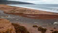
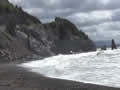
We had a cloudy but bright morning, and we set off through the woods to walk down to the beach. It is a long beach, split by a burbling brook, pretty but not spectacular. We didn’t stay long as Sandie was feeling dizzy when she looked down and was smashing her toes when she didn’t.
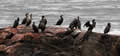 We drove the Cabot Trail, stopping wherever we could to take in the views. Some of the beaches glow with pink
  granite. Others face cliffs that drop into the sea. All of them had cormorants perched and drying their wings.
The main road turned inland but we took a loop road that hugs the cliff above Aspy Bay, a scenic drive, but few places to stop. By the time we rejoined the Cabot Trail we were in stormy weather, torrential rain and gusty winds and sunshine, all at once.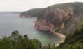
The road crossed the mountainous part of the peninsula and we came out above the Gulf of St Lawrence and dropped steeply down to Pleasant Bay. I remembered my hungry passengers being very relieved back in ’97 when we found a 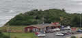 clifftop restaurant somewhere around that area.
We found it again, the Rusty Anchor. It was almost new in ’97 and its reputation has clearly spread; the car park was packed and we had to wait for a table. To Sandie’s delight they had lobster balls, but they also had crab balls. How to choose? Easy, eat both.
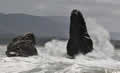 Our final stop in the park was at Pillar Rock, with the waves putting on a show. Nearby is this postcard view of the
 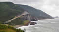 Cabot Trail winding its way up the cliffs. It’s a favoured view in all the tourism literature.
| Pillar Rock (0.40) |
 |
|---|
We came out to the town of Cheticamp, part of Nova Scotia’s French coast. By now the weather had improved to sunny and breezy and I was hoping to take a whale watching tour, but down at the dock was a sign saying that all trips were canceled because of the inclement weather. They had a point; the sea was still going wild and I don’t think Sandie would have enjoyed it.
Across the road was a government liquor store and a quick survey showed that their prices were comparable with BC’s, still outrageous by American standards, but not as bad as Newfoundland’s.