2016/08 Newf'land trip - Gros Morne |
|||||
![]() We exercised our new pass to camp within Gros Morne at Shallow Bay near Cow Head, a place we’d briefly visited in ‘89. The pass
We exercised our new pass to camp within Gros Morne at Shallow Bay near Cow Head, a place we’d briefly visited in ‘89. The pass 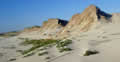 gave us a discount on camping too, not something we’d get in BC or Alberta. The sun was out and we took a windy walk on the beach, not much to see except sand dunes but nice to get out and walk on our Caribbean-like beach.
Friday August 12th
We were now into territory we’d visited before and not sure what to do.. We wanted to see new places but Gros Morne is one of the most interesting places we’ve ever been. We opted to avoid the long excursions like the hike and boat trip on Western Brook Pond and just spend a day there.
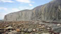
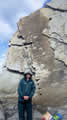 The morning was overcast and still windy, but warm out of the wind. Our first stop was a new one for us at Green Point. We arrived just as a ranger was beginning her talk on the geology of the area. We followed her down the cliff using a steep staircase, perilous in the powerful wind. Down on the beach we were blissfully out of most of it.
What faced us were these amazing cliffs, sedimentary strata turned on end by a collision of continents. About 470 million years ago, Laurentia (eastern North America) slowly crashed into the part of Gondwana that’s now Africa. Western Newfoundland, where we were now, was crumpled and tipped, while some volcanic islands were squished by the collision to form the central part. The eastern part is a bit of Gondwana, which was left behind when the continents separated again some 200 million years later forming the Atlantic Ocean.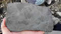
The ranger told us how she could look at a layer and see what kind of sea or lake it was deposited into. She showed us fossils in rocks from the beach. Because the layers have been tipped we were walking in time as we made our way along the beach, about 60000 years per metre.
She stayed around to make sure everyone got off the beach before the tide came in. She recommended visiting Mistaken Point way down in the island’s southeast corner and we said we would. We were talking about the rocks on the top of Gros Morne and I told her about my being attacked by ptarmigans up there, a diversion to protect their chicks. She said that climbing the mountain before mid-July was now banned to protect the nesting birds.
We were going to the Tablelands, another geological site, in the afternoon but first we had to find a campsite as this was a Friday. We drove through the park, mountains on one side and the wide arms of Bonne Bay on the other. We passed the trail head for Gros Morne mountain; when I climbed it on Canada Day in 1989 I had been the only person on the mountain; now the parking lot had overflowed onto the main road. Newfoundland’s tourism promotions seem to be succeeding.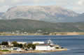
We camped at Lomond, with a view over the East Arm to Killdevil Mountain, surrounded by wildflowers. Further along the road we had this view across the water to Gros Morne itself. It looked to be solid, bare rock, but I know that the climb up is one enormous scree slope and the top is “felsenmeer”, a sea of frost-shattered rocks.
We’ve been to the Tablelands before but had to visit again. When the two continents collided part of the earth’s mantle was scooped up from the sea floor and dumped on top of this area. The rock is peridotite, which contains few nutrients for plants and weathers to a rusty orange colour. The area supports few plants and looks like a Texas desert.
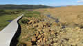 The road goes down the centre of a valley, with barren orange rock on one side and heavily treed volcanic rock on the other. In ’89 we’d
 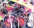 just wandered up a gully by ourselves. Now there was a nearly full parking lot and a busy trail, which took us to parts we hadn’t seen back then.
 As you might expect, this is another place where carnivorous plants do well and there were some large clumps of pitcher plants and pockets of sundews. The trail ran along the edge of the area, so there were plenty of other flowers to be seen too, all bouncing around in the constant wind.
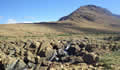
We found this view at the end of the trail. Even with the stream running through the rocks little grows in the Tablelands interior.
| Tablelands |
|---|
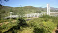 We’d hoped to also hike in the nearby Green Gardens area, possibly down to the beach, but my back wasn’t up to it and we turned around at this bridge over Wallace Brook.
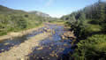
I’d enjoyed all the walking, but my back was acting up and I had a bad night. It felt like a rat was chewing on my left calf. All phantom pain but no way to turn it off.