2016/08 Newf'land trip - Trans Labrador Highway |
|||||
 Dear All,
At the end of part 1 of this journal we had just left Chelsea and Alison in Happy Valley, Labrador. We were heading south on nearly 400 miles of mostly gravel on the new 510 section of the Trans Labrador Highway to Blanc Sablon, where we’d catch the ferry across the Belle Isle Strait to the island of Newfoundland. 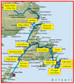
Labrador’s weather had not been kind to us so far, and this afternoon was no exception; the rain was lashing down and visibility was poor. The road soon crossed the Churchill River and began climbing into the Mealy Mountains and I stopped to take a picture of the river and bridge, but I couldn’t see that far through the murk. There were very few photos taken that afternoon.
 The road was quite good blacktop for the first fifty miles or so. We passed two work camps, presumably for the Muskrat Falls project. There’s probably a road to the dam somewhere but it’s not visible to the public.
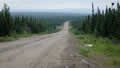
Beyond there our road was gravel, badly in need of grading. The craters were flooded and mostly invisible so we were crashing along through a constant spray until we met one of the gigantic trucks and everything disappeared. For some reason the bridges were the worst, with ruts taking us where we didn’t want to go. The picture shows the road and scenery in a brief brighter spell.
The road wasn’t built until 2010; before then the coastal communities of the southeast only had ferry service to Goose Bay. And some of those communities didn’t have a road either until 2002. Before then the locals would get around by ferries or fishing boat.
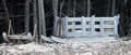
We came to a very welcome rest area and I aimed for the rear of the area to get away from the road until Sandie squawked and pointed. There was a trench running the whole width of the rest area except for a narrow connector to the rear. The trench was maybe six feet deep and ten feet across; it would be lethal after dark particularly with the rain. We had no idea of its purpose unless it was a real “tourist trap”!
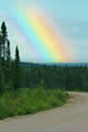
Shortly after, we passed the turnoff to Cartwright, a fishing community on the coast, about sixty miles away. There’d be no towns on our road until tomorrow. At last, the rain eased off to showers and we were briefly treated to a short stumpy rainbow.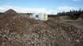
Most of the usual gravel pits we might have used for camping were closed off with a backhoe right across the entrance. They have gravel thieves here? We found a rock pit for the night, safely protected from passing traffic by great piles of rocks.
 Monday August 8th
We had sunshine at last and a sky free of rain clouds. The road was worse but much easier to handle when we could see the holes and boulders. Most drivers were choosing the best bit to drive on with little regard for left or right until they met another vehicle.
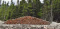
![]() We started to see traces of humans in the landscape, cargo sleds and stacks of thin logs; there were few fat trees to be seen. There were no houses, or obvious signs, so there must be general acceptance of who owns what.
We started to see traces of humans in the landscape, cargo sleds and stacks of thin logs; there were few fat trees to be seen. There were no houses, or obvious signs, so there must be general acceptance of who owns what.
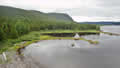 We came to a rest area with a picnic table; evidence that Labrador has a tourism budget? It had a view too, down into the valley of the
 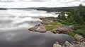 Alexis River. These pictures were taken from the river bridge, our first clear scenery in a long time and a lot of miles!