2015/11 Australia trip - Fitzgerald River West |
|||||
Monday October 26th
It rained all night and we were camped in a lake by morning. It was time to leave and see if we had better weather to the east, though this was unlikely as that’s the usual direction for the weather. We had a little more shopping to do but Borden and Ongerup, significant on the map, were nothing much in reality. However, Jerramungup, where we joined the South Coast Highway, was better with a diesel station and a general store that sold beer and Bundy rum and filled our gas bottle.
We took the Rabbit-proof Fence Road south into Fitzgerald River national park. (More about the fence later.)
Signs there stress that it’s a big park (about 40 miles wide and 30 deep) and everything is far apart. There are a half dozen roads into the park but most of them 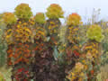
 are not connected. We hoped to use some 4wd tracks to get from the west side of the park to the east.
The road in was quite good gravel but the first 4wd track we saw was gated and closed because of dieback. Dieback is a plant disease that kills about half of Western Australia’s plant species. The pathogen is naturally spread by root to root contact, but the spread can be greatly accelerated by tyres or hiking boots, particularly in wet weather. We soon realized that all the tracks were closed.
![]() We soon found stands of the park’s most famous plant, the royal hakea. Most hakeas are identified by their elaborate flowers but this one is famous for its ornamental foliage. It’s an evergreen but as the leaves age they turn red and gold. These hakeas grow to about eight feet so they’re quite a sight.
We soon found stands of the park’s most famous plant, the royal hakea. Most hakeas are identified by their elaborate flowers but this one is famous for its ornamental foliage. It’s an evergreen but as the leaves age they turn red and gold. These hakeas grow to about eight feet so they’re quite a sight.
There were plenty of other flowers, particularly shrubs intermingled with the hakea. The landscape was mainly flat with a few distant peaks, just bumps on the horizon. It occurred to us that the park so far had little of interest other than the plants.
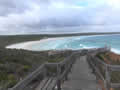
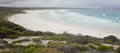 The main road in had been quite good but the spur down to Point Ann on the coast was a bone-jarring washboard. (We must be getting soft as
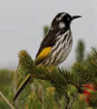 the road to Cape York was worse than this for hundreds of miles.) We found the nearby St Mary’s campground, just off the beach. We picked ourselves a site with a view of the surf and protection from the wind.
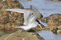 We had enough daylight left for a walk. The beach had beautiful white sand, squeaky too, and we could play tunes with our heels. Behind the beach were shrubs with red, blue, yellow, purple, and white flowers. On the beach were terns and gulls, with willy wagtails and New Holland honeyeaters around the campground.
| Point Ann (1.59) |
 |
|---|
 Tuesday October 27th
![]()
That morning we were sitting in the camper like a pair of bonobos, picking ticks off each other. Unlike the bonobos we didn’t eat them. We had more red welts too.
We were off early; we were going to take a look at the surrounding country and then head for the eastern end of the park. As the tracks were closed we’d have to drive back out to the South Coast Highway and then come back in one of the other access roads.
| Fitzgerald West (2.14) |
 |
|---|
 First though we hiked the trail through the bush around Point Ann. The overnight rain had stopped and the sun came out and so did the flies so we were
 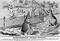 back to wearing headnets. We were being divebombed by swallows snatching the flies from around our heads. Work harder guys!
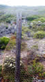
The trail took us past the ruins (posts and wire) of the rabbit-proof fence. Cape Ann was the southern terminus of the fence, which stretched across the whole country, over 1000 miles from the north coast. Building it, over a hundred years ago, was a heroic effort but doomed to failure. You have to wonder how the government thought the fence was going to survive fires, falling trees, and moving sand dunes, as well as keep rabbits from burrowing under.
As a Japanese colleague of mine said when I pointed out to him that his “fix” to a customer’s problem was worthless, “It is necessary for us to be seen to do something.” The fence was a similar fix. This cartoon of rabbits playing tennis across the fence was published long before the fence was actually built.
I![]() was limping my way around the trail. As well as my back problem I’d had a very sore big toe for the last fortnight, no sign of infection but it felt like it should have
was limping my way around the trail. As well as my back problem I’d had a very sore big toe for the last fortnight, no sign of infection but it felt like it should have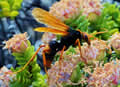 been glowing. Took my mind off the back pain anyway!
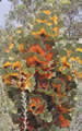
This place had even more plant varieties than the Stirlings, nearly 2000 according to Wiki. My pictures here only show a few 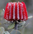 that were completely new to us. Most spectacular were these scarlet banksias, only found around this coast. We also found a few butterflies and hordes of these large and evil looking wasps. They would fly into the camper like drones checking us out. We never got stung so maybe they are flies mimicking wasps.
![]()
At the end of our walk we had to get back on the washboard to the entry road. I wanted to make one more stop to see Mount Maxwell, one of those bumps we’d seen the previous day. That road turned out to be even worse so we settled for the closer West Mount Barren, one of the places named by Flinders.
We only went up a few hundred feet but the plants there were 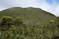 different again. The trail up the mountain had been reinforced with fist-sized rocks, too painful to walk on, so we didn’t go far.
![]()
We had not seen anyone in the park for hours and found out why when we tried to leave the park. The gate across the road was closed, to prevent the spread of dieback via the wet gravel roads, according to the sign. Luckily the sign included instructions on how to unlock the gate and then relock it.