2015/10 Australia trip - Elachbutting Rock |
|||||
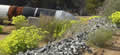 We were up before dawn and on the road soon after. Back on the Great Eastern highway we noted that the pipes we’d seen near Kalgoorlie were still running parallel with us. We found out later that they are part of the Goldfields Water Supply Scheme. Built in the late 1890s they still carry water over 300 miles from a river near Perth to the goldfields.
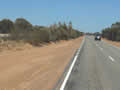
| Great Eastern Hwy (6.23) |
 |
|---|
I’d found that we also had a newer version of the leaflet map we’d been using; it had a lot of corrections and it showed Sandford Rocks as being on the other side of Southern Cross. This is a tidy little town on the edge of the Western Australia wheat belt, a convenient place to do our shopping.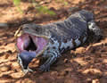
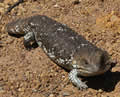
We took the turning to Westonia, a gold mine town, and blundered around until we found the reserve. This large skink welcomed us in the carpark. It’s a type of blue tongue, though the locals may call them stumpy tails or sleepies. The glare is all show; they are harmless.
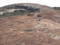
Sandford Rocks is another gigantic outcrop of granite, this time with a substantial peak which we set off to climb. There are no retaining walls so the rain water simply runs off into the forest and its carpets of flowers.
| Sandford Rocks (3.37) |
 |
|---|
![]() It was a good walk on a breezy warm morning, but the flies were a problem whenever we were out of the wind. I’d tried bug repellant but the flies thought it was people sauce.
It was a good walk on a breezy warm morning, but the flies were a problem whenever we were out of the wind. I’d tried bug repellant but the flies thought it was people sauce. ![]() I made a fly whisk out of a plant but I got tired of waving it before they got tired of dodging it. We still enjoyed the flowers though; the variety is amazing, with new species wherever we stopped.
I made a fly whisk out of a plant but I got tired of waving it before they got tired of dodging it. We still enjoyed the flowers though; the variety is amazing, with new species wherever we stopped.
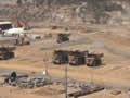
We stopped at the nearby gold mine’s overlook on our way back to the highway to gawp into the massive pit and see the giant ore carriers crawling out of the pit.
| Gold Mine (2.07) |
 |
|---|
There were lots of “blasting in 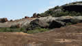 progress” signs around to deter trespassers.
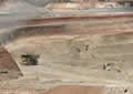
We came to the town of Merredin, well laid out, with the visitor centre facing all the town’s shops and some real grass. It was a hot enough afternoon to make shade welcome. The centre’s staff were very helpful with advice and loading us up with more leaflets and maps. We also bought ourselves a pair of headnets.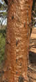
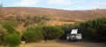
We decided to camp at Elachbutting Rock, stopping along the way for any flowers. It was a complicated route through tiny places with aboriginal names so we needed GPS help. The Tomtom said we’d be there at 8, the Garmin at 6, using very different routes. The Tomtom is set up for city streets and it minimizes the use of dirt roads, while our Garmin is set up for logging roads and will send us down a rabbit hole if it’s a shorter route! With Sandie blasting along on red dirt roads we were there by 5. 
We spotted these odd plants along the way, a tree with rough and glossy bark, a little brown shrub and a paddy melon, attractive but bitter and mildly poisonous.
We drove around the rock with its wave-like cliffs to the camping area and we seemed to be alone. Our headnets worked well, large enough to go over our Seattle Sombrero hats and tie under our chins. A built-in straw would have been useful though for drinking. We found there were always a few flies that managed to crawl 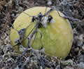 under the net but they were easily squished between net and skin.
Tuesday October 13th
Headnets were needed as soon as the sun came up. Just as well that Sandie isn’t as quick with the camera or you might have a shot of me having a wash in the sun wearing only hat and headnet. While you conjure that image I’ll continue.
| Elachbutting Rock (3.42) |
 |
|---|
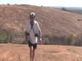
We drove around the track and found that there was a way to drive up onto the rock itself, steep but not too difficult. Up on top were these flowering shrubs, more flowers, and 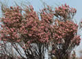 views over fields of
 ![]() wheat and canola to the west and endless bush to the east.
wheat and canola to the west and endless bush to the east.