2015/10 Australia trip - Pildappa Rock |
|||||
We were soon back on the road, with me driving. We joined the main highway towards Port Augusta, which proclaims itself to be the crossroads of Australia, with some justification with the Eyre Highway going west towards Perth and the Stuart going north to Alice Springs and Darwin.
There are massive pipes running parallel to the major highways in this area. These pipes carry water from the Murray to towns like Port Augusta and Whyalla which have little or no local groundwater. Much of eastern Australia has access to “bore water” from the Great Artesian Aquifer but it doesn’t reach this far.
 We tried to have a lunch stop at Mount Remarkable, one of our favourite parks, but found that entry now costs
$10; we wouldn’t have paid this anyway just for a lunch stop, but it had to be paid on the Internet, which we couldn’t do without a smart phone and an Australian carrier. Our plan B was the Winninowie Conservation area, which turned out be a stretch of bush with no road access, but we continued on to Winninowie itself, a village of mostly empty weekend cabins on the shore of Spencer Gulf. We drove down onto the beach, nothing special, just a nice lunch spot. The flies were back in force.
We tried to have a lunch stop at Mount Remarkable, one of our favourite parks, but found that entry now costs
$10; we wouldn’t have paid this anyway just for a lunch stop, but it had to be paid on the Internet, which we couldn’t do without a smart phone and an Australian carrier. Our plan B was the Winninowie Conservation area, which turned out be a stretch of bush with no road access, but we continued on to Winninowie itself, a village of mostly empty weekend cabins on the shore of Spencer Gulf. We drove down onto the beach, nothing special, just a nice lunch spot. The flies were back in force.
 At Port Augusta we joined the Eyre Highway; we’d be following it west for about four days. We began in wheat country but soon we were driving through scrub and bush. There was little traffic, just the occasional truck or car and caravan. Near Iron Knob we passed gigantic tailings piles, presumably the remains on the original knob of iron. Since then the miners have moved on to nearby Iron Baron and other Iron places.
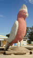
In Kimba we passed the Big Galah. Australia has a fondness for giant sculptures, and I can understand what the Big Lobster or Big Pineapple is advertising, but I couldn’t work this one out!
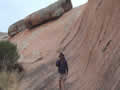
At Minnipa we turned onto a dirt road, looking for Pildappa Rock. This was one of the informal campsites in John’s book. Most of these were not significant enough for their names to be in the GPS database but the book gives their latitude and longitude, which we could input directly into the GPS.
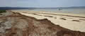
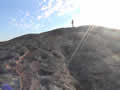
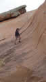
 Pildappa turned out to be a very large rock indeed. There were probably a dozen groups camping around the rock and we drove around the back and found a private spot, perfect except for the flies. We climbed up onto the rock and found that it is a pink granite dome covered with green rosettes of lichen.
| Pildappa Rock (2.30) |
 |
|---|
Up on top there are pools, some wet and some dried up and yucky, and gigantic balanced boulders, eroding from the bottom up. All around were the remains of little walls, built by the farmers to capture rainfall and guide it into cisterns.
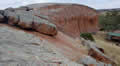
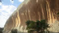
Then we saw the cliffs on either side of us and recognized them as “wave rocks”. Decades ago I remember seeing Wave Rock in an encyclopedia and believing that there was just one in the world. We visited it in Hyden in 2006 and we still believed that. Now we know that they are relatively common in granite lanscapes and result from chemical action on the granite as the surrounding topsoil erodes away.

Thursday October 8th
A noisy night with thunder and squalls of rain was followed by an overcast and windy morning. The flies didn’t care: they were waiting for us. We climbed back up on the rock to get some pictures of us on the north cliff in the morning light and then continued our journey west.
| Pildappa morning (0.48) |
 |
|---|