2015/03 Hawaii trip - Kilauea's Byron Ledge Trail |
|||||
 Monday March 9th
Connie had brought us this lobster claw cutting from her garden and added it to the gorgeous flower display that sat next to the living room Buddha. Sadly, this was to be our last day  in Hawaii, but we weren’t flying until the evening. We partially packed, loaded up the car, locked up the cottage, and headed up the road to Kilauea for a last day of hiking. The weather was not cooperating and we had a very wet morning.
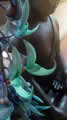
This was a good reason to stop on our way at Volcano’s Akatsuka orchid garden, really just a large shop, but admission is free, hoping you’ll end up buying something. They ship orchids anywhere in the world except for four places, one of which is Canada, so I was reasonably safe. Nice to know that government  regulations are protecting Canada’s vital orchid industry. It was actually a beautiful show and we stayed until a couple of buses arrived and the place became crowded. This photo is just one of the dozens Sandie took. It was still raining.
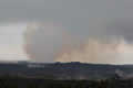
The plan was to hike the Byron Ledge Trail, which the map showed as connecting the Kilauea Iki crater with the main caldera. But while we were sipping our lattes at Volcano  House, we watched as all the scenery in the caldera and the Halema’uma’u crater disappeared into the clouds. Hiking in the rain is OK, but not when we can’t see anything.
Instead we drove to the end of the Chain of Craters Road, just beyond where we’d been for the petroglyphs. This is where people used to come to watch molten lava crash into the sea. Now that the lava is flowing elsewhere, the road has been closed; it is being rebuilt to cross the recent lava flows and join up with where 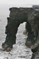 we’d been on our first day in Puna, at the current end of Highway 130. Unless, of course, the volcano chooses otherwise …
Walking the road beyond the barriers is forbidden, so the only reason to go there is to see the Holei Arch, an oddly eroded section of lava cliff. Although the cliff is about thirty feet high, there are warnings that freak waves sometimes crash over the cliff. The waves have plenty of room to build, with only a few dots of islands between there and Antarctica. And warnings too that the cliffs are honeycombed with caves and blowholes and prone to sudden collapse. The park service has reinforced a few spots to reduce tourist loss.
| Holei Arch (2.53) |
 |
|---|
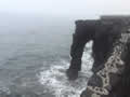
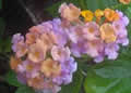
 Behind us was another cliff, the massive Holei Pali. It was our first view in good daylight, and a reminder that this whole section of the coast below the fault scarp is slowly sliding into the sea. We ate lunch overlooking the ocean and then headed back up the road, where Sandie spotted yet another orchid, this “nun’s hood”, probably an escapee from one of the gardens. Nearby was this multicoloured lantana, similar to those in Australia and probably also an invader.
We arrived back at Kilauea’s caldera, where the rain was still heavy and the view was still socked in. But what else was there to do? We set off anyway. The trail we were following used to be the Crater Rim Road, but parts fell into the caldera during an earthquake back in 1983. So now it’s the Crater Rim Trail, weaving around the missing bits and taking us down to our target, the Byron Ledge Trail. Happily the rain had eased off and we could now see columns of steam 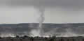 coming from the caldera floor.
The trail took us right down to Kilauea’s caldera floor, a few miles of mostly flat lava, solidified from a lava lake, and still warmed by the molten lava just below. Plants like the 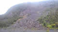 ohia were already growing from cracks in the lava. In the distance was the Halema’uma’u crater. Its lake of molten lava was a few hundred feet down and we were quite happy for it to stay there! There is a trail directly across the caldera to the crater, but it’s been closed since the 2008 eruption, when the crater began to emit volumes of sulphur dioxide.
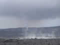
Above us towered the caldera’s cliffs, some of them steaming and some decorated with great piles of boulders, landslides from the ‘83 quake, including this one that took out the old road. While we were there the clouds billowing from the crater changed colour to orange. I took this final picture. It looked like something dramatic was happening but to our relief the colour faded away.
| Kilauea caldera floor (0.51) |
 |
|---|
The rain was back and our view faded away too. We climbed back up to the car, changed clothes and footwear, and finished our packing. Our suitcase was five pounds heavier, most of it probably rainwater. We flew from Hilo to Honolulu and there picked up Alaska’s redeye flight to Bellingham. We wouldn’t sleep very well but the good news was that it was a direct flight and we’d arrive in time for breakfast.
Sandie had an appointment to keep that afternoon in Hope. Things were looking good as we were twenty minutes early, but Bellingham was fogged in. The pilot had to abort the landing and blast us back up out of the fog as he couldn’t find the runway. A second try failed too. The pilot was talking about landing in Seattle as we didn’t have enough fuel to keep circling, so we were all relieved when the third attempt was successful, even though it looked like we landed halfway down the runway, with extreme braking. After all that we found that the TransCanada Highway was closed by an accident; Sandie kept her appointment with seconds to spare.
All was good at the house, and our railings had been repaired while we were gone. From what we could see in town it looked like spring was coming two weeks early, with forsythia, magnolias, and camellias in flower.
It had been a great vacation: Hawaii exceeded our expectations