2015/03 Hawaii trip - Waipio Valley |
|||||
Saturday March 7th
We were going to explore the Waipio Valley in the north of the island, but first we had Connie and Andrew coming for coffee and munchies. They sang out loudly before coming in sight, an obvious precaution when there’s an outside shower. We mostly talked about traveling but we could really relate to their stories about building the cottage, back before Hilo had a good hardware store. They would come back from the Kona-side Home Depot with their truck full to overflowing. Despite that they’d made a great job of the cottage; we really liked what they’d built. Andrew is a building contractor and he said he has a constant battle to keep his workers at work. As soon as they have enough cash in their pockets they’ll take off surfing for a few days.
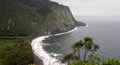
Eventually we had to leave for the two hour drive up the Hamakua coast to Honoka’a where we were picking up the shuttle bus into the Waipio Valley. We arrived in showers with minutes to spare. Normally it’s just a tour but I’d arranged for them to drop us off on one tour and pick us back up on the next. The valley is famous for its great green cliffs and the waterfalls that plummet over a thousand feet from the cliffs into the valley.
 One of the waterfalls is visible from the top of the road, but to see the others you have to take the very steep 4wd track into the valley and
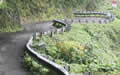 then cross a few rivers; hence the need for the shuttle, as few rentals can deal with such terrain. Our driver took us down the track in a van, all the while keeping up a commentary about the valley’s history. Thousands of people used to live there, and the valley floor was a garden, cultivated for taro, a potato-like crop, but it grows in water, like rice. Kings lived in the valley with many wives, and many sons vying for power. Warfare seemed to be continual with lots of killings until Kamehameha, with the help of European weapons, became king of all the islands.
| Waipio (5.30) |
 |
|---|
 The valley and its gardens were inundated by the 1946 tsunami. Yes, as well as eruptions and earthquakes and hurricanes, this place
 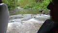 gets tsunamis; they come in from Alaska, Chile, Japan and Indonesia, the whole Ring of Fire. The valley is now occupied by around a hundred people, some of them hermits. Many of the properties are owned by extended families so they are difficult to maintain or tax or sell. On the upside, this has so far kept the developers out.
It was a good (wet) time to visit the valley. The waterfall we’d seen from the top doesn’t even appear on most pictures we’ve seen. The driver took us across rivers and even up the rivers, as far as he was allowed, and we had a good view of Hi’ilawe and Hakalaoa, the falls that drop over a thousand feet from the valley’s headwall.
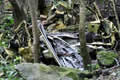
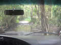
 He dropped us and a Honolulu couple off at base of the track and we walked to the beach, taking diversions around the massive puddles. In the jungle below the cliff were the twisted remains of vehicles that had taken the quick way down.
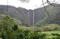
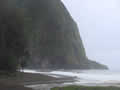
At the black sand beach the surf was booming but not high enough for the surfers to be enthusiastic. We ate our lunch on the beach in fine drizzle with some interest from this yellow billed cardinal. Just behind us, Kaluahine Falls was flowing down the cliff. It wasn’t until we got close to the surf that we saw another, further along the cliff, Waiulili Falls I think, just visible 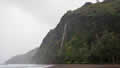 through the drizzle in the picture. Even the beach was scenic, with foamy white surf drawing curvy patterns on the black sand.
| Waipio Beach (2.16) |
 |
|---|

As arranged, we were collected by the next shuttle up, getting envious looks from hikers just starting their climb back up to the parking lot.
On our way back to the cottage we stopped in Honoka’a for a snack at Grandma’s “Kichen”; luckily her food is better than her spelling. The locals were complaining about the cold, made even worse as Grandma’s lights and ceiling fans were on the same switch. They said it was the coldest day of the winter, somewhere in the mid-60s.