2015/03 Hawaii trip - Kilauea's chain of craters |
|||||
 Monday March 2nd
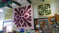
This was probably going to be our last day in the Kilauea park, exploring the Chain of Craters area. It was a wet morning in Keaau and we hoped to get above the clouds. Just outside the park we left the rain behind and went into the village of Volcano, looking for its coffee house (our third attempt). We finally found it hidden behind the gas station. Next door, improbably, was Kilauea Kreations, a large shop packed with quilts and books and stuff. Sandie had a good time.
The Chain of Craters road connects the caldera to the south coast and there it used to connect with Puna’s highway 130, where we’d been the previous Wednesday. Lava flows had destroyed the road repeatedly over the last thirty years, but now that the lava was flowing east and threatening the Pahoa 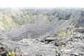 area, the road was going to be rebuilt as an emergency access to the Puna area, albeit fifty miles longer. The government was also
 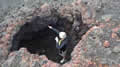 upgrading a more direct rough coastal road but if the new lava flow continues all the way to the sea then it will take that one out too.
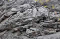
The Chain of Craters road took us, as expected, to a number of now extinct craters, some recent with stark black lava, others older and now choked with new forest growth. The lava had cooled in strange patterns leaving tubes and caves and arches, fun to explore if you avoid the sharp bits! The major attraction on this road used to be the opportunity to watch the lava flowing across the road and into the sea, dangerous but exciting. Now the lava is flowing through rough country outside the park, with no access roads.
We were beginning to appreciate the complexity of the Kilauea volcano. It’s very different from the classic volcano model with steep flanks topped by a single large crater. We’d already seen two large craters, one still active, and now we were visiting a lot more of varying ages. And the current eruption was happening somewhere else! Since 1983, lava has been flowing from the East Rift Zone close to the park’s boundary, mostly from the Pu’u ‘O’o spatter cone, but sometimes from neighbouring craters.
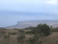
![]() We took a drive along the single lane Hilina Pali road. It twists and turns through some interesting country with trees and shrubs mixed with weird lava formations. It would have been more enjoyable if the other drivers had wanted to see what was along the way rather than get to the end and blast their way back. It ended at the top of the “windy cliff” with a view of the southern coastline far below us. It was a murky view, as the weather was catching up with us, visible on our right. The cliff marks the fault line where the coast has so far slid 1500 feet down the mountain.
We took a drive along the single lane Hilina Pali road. It twists and turns through some interesting country with trees and shrubs mixed with weird lava formations. It would have been more enjoyable if the other drivers had wanted to see what was along the way rather than get to the end and blast their way back. It ended at the top of the “windy cliff” with a view of the southern coastline far below us. It was a murky view, as the weather was catching up with us, visible on our right. The cliff marks the fault line where the coast has so far slid 1500 feet down the mountain.
| Hilina (0.36) |
 |
|---|
![]() Back near the main road, we began hiking the trail to the Mauna Ulu cone. This cone was created by a five year eruption back around 1970 and it’s still steaming. This was our view as we began our hike. The trail began near an area of tephra; that’s the lighter stuff that gets blasted out when the lava is fountaining out of the ground. It includes cinders, pumice, Pele’s tears (shiny black droplets) and Pele’s hair (threads of lava). Pele is the goddess of the mountain and the centre of the old religion.
Back near the main road, we began hiking the trail to the Mauna Ulu cone. This cone was created by a five year eruption back around 1970 and it’s still steaming. This was our view as we began our hike. The trail began near an area of tephra; that’s the lighter stuff that gets blasted out when the lava is fountaining out of the ground. It includes cinders, pumice, Pele’s tears (shiny black droplets) and Pele’s hair (threads of lava). Pele is the goddess of the mountain and the centre of the old religion.
| Mauna Ulu (2.37) |
 |
|---|
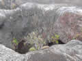
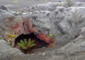 The vents in that area were very colourful, stained with reddish haematite. The rain had caught up with us and I suggested we eat lunch in a pretty cave I’d found but Sandie didn’t think it looked very inviting so we ate in the car instead.
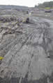
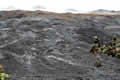
 We continued when the rain paused and by the time it restarted we were already committed to the hike. The trail took us across lava fields and through a kipuka, a piece of forest the lava flowed around. The trail was quite rough with surfaces at all angles and eventually we were just following cairns of rocks across the lava plain, with the wind blowing the rain in our faces. The lava plain was mainly pahoehoe, but even that can be difficult when it’s a mass of twisted ropes like those in the picture.
There was a great shaggy hill to our left and a wall of lava to our right. We met some other hikers who said there was no payoff at the viewpoint for all this walking, just fog and cloud, but we plodded on anyway. The walking got easier as we reached a smoother section that looked like it had once been a river of lava flowing across the plain.
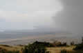
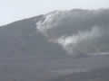
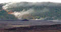 We didn’t find the viewpoint and we eventually concluded that we had missed a turn and were on the wrong trail. The rain had stopped and the clouds were clearing, and I spotted a zigzag of steam coming down the hill ahead of us. Sandie looked through her camcorder and noticed that the ground beneath the steam was orange. We realized we were looking at Pu’u ‘O’o, the source of the current “East Rift” lava flow, and the orange bits were molten lava, flowing down the slope and across the plain. The forest looked to be burning around the edges of the flow.
This was a bit of a surprise. We were still at least a mile away but had no idea what gasses were flowing so we backtracked, found the turning we’d missed, and climbed up the shaggy hill to the overlook. By this time the weather had luckily cleared and we had a good view from there of both the lava flow and the steaming hulk of Mauna Ulu. We found out later that we’d been accidentally following the Napau Crater trail, closed to anyone without a permit.
| Pu'u 'O'o (1.49) |
 |
|---|
 We had enough daylight for one more stop, so we drove down the steep Holai Pali, another part of the fault line, to the coastal plain and
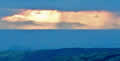 the location of the Hawaiian petroglyphs. They turned out to be at the end of another trail across the lava, and protected there by a boardwalk. They were the usual mixture of stick figures and geometric patterns, interesting, and we had the bonus of our first (and last) Hawaiian sunset. I’d always envisaged a sunset picture as including beach and palm trees, but mine only has black lava and deep blue ocean. Of course, coming back across black lava in the dark was problematic but we had a headlight with us.