2015/03 Hawaii trip - Puna |
|||||
On our way out we met Andrew; he and Connie live on the same road. He’s from Geelong, near Melbourne. He ended up in Los Angeles, where he married Connie, but never took to living in LA. On a vacation he discovered Hawaii’s Big Island, a piece of America that’s almost Australian, so that’s where they now live. He thought that the area had a 1960s feel about it, rather like Queensland.
We were going to spend the day in Puna, the southeast corner of the island, while we still could. There was a possibility of the road being cut and the area cut off. This sounds odd, so I’d better explain. All the islands are volcanic, the result of the Pacific plate slowly sliding northwest across a “hot spot”. The hot spot creates volcanoes which grow from the sea floor to become islands and mountains and then become dormant as they slide away from the hot spot. Eventually the volcanic rock erodes away and the island disappears. The other Hawaiian Islands are all dormant or extinct volcanoes.
The Big Island has five volcanoes, two of which are still active. Mauna Loa is gigantic at over 13000 feet, and it has been quiet since 1984. Kilauea is much smaller, a wart on the side of Mauna Loa, but it has been erupting continuously since 1983, making it the world’s most active volcano. If you’ve seen videos of molten lava crashing into a boiling ocean, chances are that it was coming from Kilauea. However, last June, the lava began flowing to the east towards the town of Pahoa, and back around Christmas it was advancing at a hundred yards a day and was about 500 yards from the only highway into town.
![]() I took this picture from the air a week into our trip and it shows just how close the lava flow (black) had got to the shops at the left. Michelle told us the locals had gone to the nearby garbage dump to watch the lava flowing. Since then that flow had stalled but others were coming down in parallel, broadening the lava field. The smoke to the right comes from trees burning from a “break-out” of molten lava.
I took this picture from the air a week into our trip and it shows just how close the lava flow (black) had got to the shops at the left. Michelle told us the locals had gone to the nearby garbage dump to watch the lava flowing. Since then that flow had stalled but others were coming down in parallel, broadening the lava field. The smoke to the right comes from trees burning from a “break-out” of molten lava.
Our cottage was about five miles from the flow, on the airport side. Cottage owners on the wrong side, in Pahoa and the rest of the Puna area, were having a tough time renting their properties. Pahoa is also famous as Hawaii’s outlaw town, home to guerrilla gardeners and those who like to separate themselves from government. If the Big Island is still in the 1960s then Pahoa is its hippy capital.
We drove highway 130, the one that’s at risk, stopping to shop at the Pahoa Marketplace, the likely target if the lava flow resumes. Nearby was the newly built Malama Market, “opening in March”, but they must be wondering if it’s worthwhile to bring any stock in. We soon reached the end of the road and were flagged down by a highway worker who told us that the rest of the road was in process of being rebuilt. “For the fourth time”, he said. He suggested we 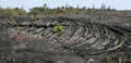 take a side road down to the coast and take 137 instead.
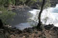
We did, but the coast road also dead ended, this time at a wall of black lava that covered everything between the forest and the sea. This was Kaimu Beach, and beyond that the town of Kalapana, mostly buried in 1986 and then given a fresh coating in 2010. The luckier people were the ones whose houses were destroyed as they could collect on their insurance. 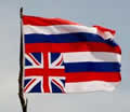 The unlucky ones had houses that were untouched but cut off from roads and services. No damage, no pay out. Other homeowners saw their oceanfront properties cut off from the sea by some newly created land. This is termed “accreted land” and it belongs to the state, not the homeowner.
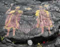
The remaining locals had some stalls set up selling souvenirs and pictures and some of the flatter sections of lava were adorned with art and sculptures. We bought some  photos from the 2010 eruption, mostly taken from the photographer’s fishing boat. Flying over the scene was the flag of the state of Hawaii, eight stripes, one per island, with an embedded Union Jack, a relic of the days when the “Sandwich Islands” were allied with Britain. One of the paintings was of the coat of arms of the Hawaiian Kingdom, possibly by one of the groups that want to end the current occupation by the United States and restore the Hawaiian monarchy, difficult to achieve now that Hawaiians are a small minority.
| Kaimu Beach (5.31) |
 |
|---|
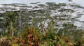
We walked across the lava to the new coastline. This is pahoehoe lava, all shiny swirls and ropes and pillows, relatively easy to walk on. The waves were pounding in, as they do all around the island. Hawaii is thousands of miles from any continent so the waves have plenty of time to build. Lava is mostly soft with many fractures and cavities so it erodes quickly and there was already a black sand beach below us. Coconut palms were already growing around the trail, planted by the locals we thought.
We stopped for smoothies at the somewhat ramshackle Uncle’s Awa Club. A smoothie is a jug of frozen tropical fruits blended to baby food consistency. Depending on the fruits chosen some are better than others.
We drove along the coast looking for a nice beach to eat our sandwiches, but Puna mostly has lava cliffs a long way above the beaches. We found this black sand beach with a trail down that wasn’t too dangerous, but all the people on the beach there were naked and Sandie wasn’t willing to risk that much sunburn.
 We’d heard from Terry about the warm pool at Ahalanui Beach and our GPS took us there along a decayed beachfront road that
 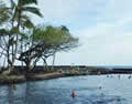 eventually disappeared into a mass of dead vegetation, debris from some storm. To my surprise, Sandie found me a route through it but that involved crossing some lava flows; at this rate the rental wouldn’t last the week.
The pool was interesting, protected by a barrier from most of the waves, though there was a connecting channel and the biggest ![]() waves would come over the barrier. The pool is heated by volcanic action and gets very warm at low tide, but at high tide we had a mix of hot and cold. Still a nice float though.
waves would come over the barrier. The pool is heated by volcanic action and gets very warm at low tide, but at high tide we had a mix of hot and cold. Still a nice float though.
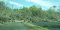
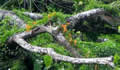
 We moved on to Lava Trees park. Back about 200 years ago a very fluid lava flow swept through the forest, burying and killing the trees. The flow went off downhill, but the lava had cooled and solidified around the trees, leaving molds of the trunks. The signs mentioned the magnificent trees that now occupied the space. There were a few gorgeous stands, but they had mainly gone, replaced by great heaps of debris and sawdust, the result of Cyclone Iselle that blasted its way across the islands last August.
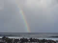
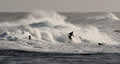
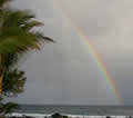
We went back to the coast, along this very pretty road which had somehow escaped the hurricane. We watched the surfers 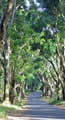 and rainbows at Isaac Hale beach, and then drove a somewhat beat-up road down to Cape Kumukahi.
| Isaac Hale Beach (6.55) |
 |
|---|
The lava on either side of the road is the more viscous “a’a”, giant pieces of clinker, loose, broken, and sharp, almost impossible to hike across.
 The town of Kapoho used to be near here; the residents woke up one morning in 1960 to find that lava was pouring out of a new vent in a nearby sugar cane field, and within a few days it had destroyed the town. Living on a volcano can be interesting.