2014/06 Haida Gwaii trip - Nass Valley |
|||||
Thursday July 3rd
They were still out and hungry in the morning so we didn’t stay around long. We drove into Terrace for sewer, water, and phone. We could have headed directly for home, but it seemed a shame to be in the area and not take any side trips. After seeing the signpost on our way up, I’d been doing some research into the Nass Valley and had found that it had lava beds and a 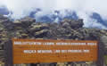 brand new Nisga’a museum so it was worth a visit.
The Nisga’a Highway is a winding, heavily forested road with the occasional one-lane wooden bridge to keep the driver awake, obviously an upgraded logging road. We came to Lava Lake, and beyond there were the beds of lava. The park is jointly managed with the Nisga’a nation. It used to be the Nisga’a Memorial Lava Bed park, but now it has the new catchy name in the picture.
250 years ago this was the site of Canada’s most recent volcanic eruption, possibly linked to a massive earthquake that occurred around then. There was nobody in the Nass Valley keeping track of dates back then but the Japanese recorded a massive tsunami that’s thought to have come from the northern BC coast.


The Nass Valley already had a cinder cone and lava beds, but this was a violent outflow of gassy lava which diverted rivers, created lakes, and overwhelmed the Nisga’a villages, killing around 2000 people. Today, the lava beds are tens of feet thick and difficult to traverse; it’s what the Hawaiians call a-a lava, sharp and spiky.
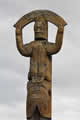
We found the visitors centre, housed in this reproduction long house, viewed the art exhibits, including this spectacular mask, and picked up a map of the trails and villages.
 Even where a trail has been cleared, hiking across the lava is difficult, all clinker at strange angles. After 250 years, plants are growing, mainly yellow and green lichen with splashes of red sedum, but there are trees wherever there is water. Streams run underneath the lava, but during floods they’ll come to
 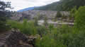 the surface and scour deep channels in the weak lava. We were following a trail along the channel in the picture when it dead-ended with warnings not to go further into a sensitive area, not that it looked inviting anyway.
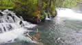
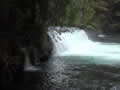
We took a short walk to the Vetter Creek waterfall, a very wide low falls, quite pretty with its four separate cascades. Downstream the creek disappears under the lava bed.
| Nisga'a Vetter Creek (2.56) |
 |
|---|
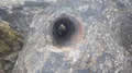 We took a lengthier hike out to see the tree moulds. It looked like the trail had been scraped clear with a bulldozer, but there were still some massive
 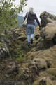 cracks in the ground. We found a couple of moulds, places where trees had been covered by lava and then burned completely, leaving the shape of the tree trunks. Botanists have identified the tree species from the preserved bark imprints.
The trail continued so we followed it, but it was getting more and more difficult with some climbing amongst sharp unfriendly chunks of lava. We felt like Sam and Frodo at times, but we gave up before we reached Mount Doom.
The prime hike in the park is to the Tseax cinder cone that caused all the excitement, but one can only do this with a Nisga’a guide. We’d thought about doing this but it’s several hours of hiking, really tough in this terrain, and this trail convinced us not to try.

There are four Nisga’a villages in the area beyond the lava. We had just enough daylight to visit Gitwinksihlkw, the closest. As you can see from the sign, they have wolf and 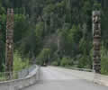 orca moieties as well as the Haida’s eagle and raven. This spills over into their art which is more varied I think than the Haida’s. Their new bridge over the Nass River is adorned with a splendid pole on each corner.
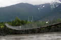 The river was a surprise, much bigger than I would have guessed; it flows to the north of the Khutzeymateen and empties into Portland Inlet. In the village I walked out on the narrow suspension bridge that until recently was their only access to the rest of the world.
We’d finally run out of daylight and camped in the easiest place to find, the park’s campground.