2014/06 Haida Gwaii trip - Prince Rupert |
|||||
Thursday June 19th
On a drizzly morning we crossed the Skeena into Terrace and then the railway line that cuts the town in two. We passed signs for a highway that goes north to the Nass Valley and some unpronounceable towns; we filed this away for exploration on the return trip.
 There are no towns in the 100 miles between Terrace and Prince Rupert, just the highway, the railway, and the mighty Skeena. We were
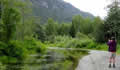
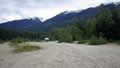 looking for a coffee stop and the map showed a recreation area on the Exstew River. We followed an ancient overgrown logging road through forest and swamps until the road disappeared underwater. There aren’t any crocs in Canada so a bit a wading showed that we’d be OK; the truck is a diesel after all. The road eventually brought us out onto a massive shingle beach on the Exstew River, a great camping spot surrounded by snow streaked mountains, with a large, distant waterfall.
| Exstew River Road (7.41) |
 |
|---|
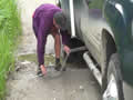
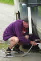 There were billions of granite pebbles but few of any interest to Sandie. We explored for a little while; there were traces of other people there but we didn’t meet anyone. On our way out, the bumps and extreme angles caused one of the chains that hold the camper to the truck to come loose and fly off. Luckily this was in one of the drier sections, and I was able to find all the bits and put it back together.
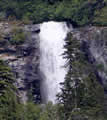
Back on the highway in light rain, we stopped at Exchamsiks River for lunch, mainly out of curiosity. Back in 2004 we had tried to camp there only to find that all the campsites had been red-taped, closed because the grizzlies there had been snacking on tourists. This time we found that the road to the campground was blocked by concrete blocks and had been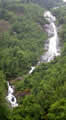 allowed to degenerate into a hiking trail, definitely a win for the grizzlies. A little way beyond there we came to this tall waterfall, which we’d missed on our previous trip (in the other direction).
We passed the tidal stretches of the Skeena and took a quick look at the Prudhomme Lake campground to check that there was plenty of room, and then we crossed the channel over to Kaien Island and dropped down the hill to Prince Rupert. We would be catching the ferry early the next morning and needed to check out the ferry’s location and do a little shopping. Prince Rupert looked to be doing a bit better than it had ten years ago; the new container port must be helping.
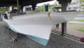
Like last time we ended up at the touristy area around Cow Bay, still in the drizzle. One of the oddities there is the Kazu Maru, a Japanese fishing boat that crossed the Pacific with the Japanese Current. No trace of its skipper was ever found and it’s now part of a mariners’ memorial.
We filled up with diesel, reckoning that it would be more expensive on Haida Gwaii. In the distance we could see what turned out to be Butze Rapids, one of many areas on the BC coast that turn into raging rapids when the tide turns and a lot of water goes through a narrow gap. There’s a long trail for a closer look, but we never had the weather for it. Prince Rupert is the wettest city in Canada.We took a side trip to Port Edward, at the mouth of the Skeena.
Next