2013/06 NWT trip - Prelude Lake |
|||||
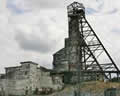 We drove out east along the Ingraham Trail, NWT 4, past a number of open pits and the ruins of the gold mines that gave birth to Yellowknife in the 1930s. When the gold ran out, Yellowknife became a government town, but then diamonds were discovered northeast of town in the 1990s.
The road was awful even by NWT standards, with frost heaves on sharp corners, but the scenery became quite pretty, with lakes and rocky cliffs and islands. At Prelude Lake, we found that there had been a cancellation and we had a camp site now rather than the overflow area. The rather odd ranger explained that the “rich people” rented about half of the campsites for the whole season, leaving their trailers on site.
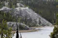
We walked the nicely boardwalked panorama trail high above Prelude Lake, much like the big lakes up on the Minnesota/Canada border, Kabetogama or Namakan. Granite domes and cliffs dominate the scenery around the lake. We were tempted to put the boat in, but it was a bit too breezy for kayaking, and we just cooked over a fire, retreating inside as a light rain came in across the lake.
There was a constant hum that night as the “rich people” arrived and fired up their generators. 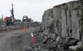
Saturday June 15th
We made a late start on a drizzly, cool morning. It was too wet to walk the local nature trail, so we set off to the end of the road, the Ingraham Trail. The road became worse; it was being rebuilt, so we had some long waits while the crew blasted out some rocks and then we and the rest of the traffic would drive over the craters. We passed lake after lake, most with sandy beaches or boat ramps.
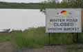
The road ended at Tibbet Lake; this is where the Contwoyto ice road begins in winter. The ice road services the Diavik and other diamond mines and goes on to Contwoyto Lake in Nunavut, some 500 miles away. 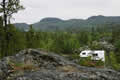
A bunch of Indian teenagers were fishing at the boat launch while others were washing their truck, a combination we’d seen before though why they bother when the roads home are thick with mud I don’t know. We didn’t understand any of their chatter, presumably in one of the seven Dene languages in the area.
I climbed up to one of the ridges to get a view to the east, rocky hills with mountains behind, interesting but no easy way to get there. The bugs down on the road weren’t too bad but as I walked along the ridge I was covered in mozzies.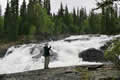
We drove back to Cameron River Crossing and took the short trail to the river’s Rampart Falls.
The bugs were bad up on the ramparts too, odd as the high places are usually OK. The falls were spectacular and easy to get close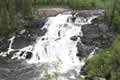 to. We went on to another trail, this to Cameron Falls further down the same river. This was a longer trail up and over granite domes before dropping down to the falls. My first thought was that we’d ended up at the same place, as the two falls are very similar. Even now, I have trouble sorting out the two sets of photos.
By this time our truck and camper’s muddy exterior was covered in even more mud.
 All this hiking had been in fine drizzle, but by the time we returned to Prelude Lake it was almost dry, and we took the opportunity to walk the nature trail. It took us up and over dozens of granite domes, with views of the lakes below. Half way round a steady rain set in, obscuring the views and giving us some slippery descents; I could have done without those.
Back in camp, the generators were still going and we only saw the campers when they emerged to fill up the generator tanks. We felt superior, but we were covered in mud and dead mozzies and they were warm and dry!
Next