2012/07 Western Canada trip - Marble Canyon |
|||||
![]() Then we were off south to Kamloops, over the mountain and down to the desert country around Kamloops Lake. On the hillside above the
Then we were off south to Kamloops, over the mountain and down to the desert country around Kamloops Lake. On the hillside above the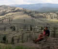 lake we could see relics from the flumes built to irrigate the orchards of Walhachin. This was a British community formed just before the First World War, and it disappeared when they returned to Europe to fight.
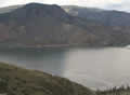 We stopped at an overlook where we could see both the lake and the two railway lines. John was hoping to get a picture of an entire train, but the one that came along had about 200 cars, too wide an angle for his lens.
Our first possibility for a campsite was Juniper Beach on the Thompson River, attractive but too crowded for us. Nearby Walhachin Oxbows turned out to be a park with no roads, so we continued on towards Marble Canyon on the other side of the town of Cache Creek. I’d thought that the park would be up a side canyon, but it turned out to be just below the main road, squeezed between the canyon’s cliffs and a couple of lakes. The road wasn’t a problem; highway 99 connects Vancouver with Whistler and Cache Creek, but this piece of it is really quiet.
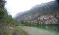
Marble Canyon is actually crumbly limestone, and we could hear the occasional small avalanche of rocks hitting the barriers around the  road. The lakes are quite pretty; Crown Lake is bluish and Turquoise Lake is more of a light green, visible in this reflection. There were plenty of fish to be seen and we had a pair of loons calling; it was just like sleeping up at Voyager Village.
 Wednesday July 25th
We had a dry morning, and we walked around the lakes until we started to stick in the mud. We saw the loons and some kind of sandpiper.