2012/07 Western Canada trip - Bow Lake |
|||||
 At the park entrance, we paid for four days’ admission. Canadian national parks cost more per day that most American parks do for a
  week. The cost of camping is on top of that.
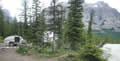
We went directly to Rampart Creek campground, and as I’d hoped we were there in time to take one of the prime campsites on the river’s edge. What I hadn’t expected was the size of the North Saskatchewan River, full from bank to bank, and roaring 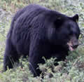 past just below our site’s level. On our last visit there we’d had trails to walk and meadows to explore, but this year they were all underwater.
I suggested that we spend the afternoon at Bow Lake, about 40 miles south. On the way, the road crosses the North Saskatchewan River, with some beautiful views from the bridge. I usually stop there if it’s a fine day, but there was no choice this time as there was a large black bear feeding beside the bridge and traffic was at a stop until the bear moved on.
 We had lunch beside Cephron Lake, always a beautiful spot, but better when it’s calm and sunny. We had neither at the time.
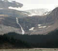
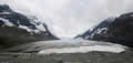
At Bow Lake we set off walking the trail towards Bow Glacier Falls. As you can see from the picture, this is scenery on the grand scale, 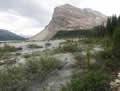 and the falls are a long way off. I wasn’t planning to do the whole walk this time but there is a breathtaking view of the falls and the glacier from the ridge at about the halfway point. But we didn’t even make it that far. The trail around the lake was under the lake in a few places. Beyond the lake there’s usually an easy section along the gravel bars of the creek, but the creek was running too high and we had to use an impromptu trail through the woods. We gave up when this became too difficult and muddy.
It was too early to give up on the day though and we drove north into Jasper park to visit the Columbia Icefields without the usual daytime crowds. The light 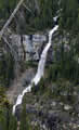
 was still good but there was a cold wind screaming down the glacier, so the few people there were moving around quite briskly. John and Edna could see how much the glacier had retreated since their first visit back in 1993 and even since their last in 2001. The current parking area had been underneath the glacier on our first visit thirty years ago. Now it’s surrounded by the tributaries of the Sunwapta River, and carpeted with fireweed.
 We climbed up and over the terminal moraine, but the glacier itself was roped off and inaccessible. On our last visit some parts of the glacier were considered safe enough to walk up but there have been enough recent accidents to stop this. People who fall into a crevasse usually die of hypothermia before they can be rescued.
 If you look closely at the picture of John and Edna descending the moraine, the rocks in the foreground have fresh scratches from the glacier’s action.
There was still some light left so I thought we’d drive a little further to see the sheep that often hang around Tangle Falls. There weren’t any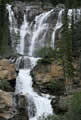 there but the falls were roaring with all the recent rain. Everywhere we looked there were waterfalls like Bridal Veil Falls above, crashing off the cliffs, often spectacular but usually inaccessible. In contrast, Tangle Falls are always pretty and are often covered with kids climbing around the rocks. This time we had the place to ourselves for a while.
Sandie, Karen, and the boys had arrived in Hope after a camping stop in Revelstoke. Their trailer fit completely within our garage with some good backing from Karen. Sandie was busy yanking barrow-loads of weeds out of the garden. She said we’d had some warnings from the district about the Fraser’s dangerous river banks, undercut by this year’s high water.