2012/07 Western USA trip - Sinks Canyon |
|||||
Friday July 6th
I’d worked out a route up to Canada that gave us about five days in Yellowstone and Grand Teton with a few interesting places to camp en route. We’d be going to Sinks canyon in Wyoming and then on to Grand Teton for a couple of nights and three in Yellowstone, exiting via Bear Tooth Pass. Although we’d be arriving at the weekend, that’s OK for the Yellowstone area; it’s so far from major cities that most people take 3-4 days to get there. Peak arrival day is Tuesday.
The rest of our 1000 mile trip to the Canadian border would be mainly driving. The obvious place to go was Glacier national park, right on the border, but we were about six inches oversize for every dimension restriction on the Going to the Sun road. There are shuttles but not many and not big enough, so we were bypassing Glacier. [Karen later confirmed this. On an earlier trip, they’d waited so long for a shuttle with space they’d had to give up and take the car.] 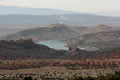
 Another factor was that my I-94 entry permit to the USA expired on the 16th.
We shopped in Vernal, our last stop in Utah, and headed north on US191, climbing through a coloured landscape of rocks and cliffs up to a high plateau. All along the road were signs describing the geological formation we were currently driving through and the kind of fossils contained in the rocks. And reminders not to dig them up. A viewpoint ![]() provided by a potash mine gave us this view back down towards Vernal and another of the red and white cliffs ahead.
provided by a potash mine gave us this view back down towards Vernal and another of the red and white cliffs ahead.
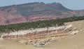
The plateau gave way to steep hills and forest as we dropped down to the Flaming Gorge reservoir. The dam impounds about 90 miles of the Green River, upstream from Dinosaur. It’s a great spot for water skiers and power boaters, but a lot of pretty country went underwater when the dam was built. Somewhere along that lonely road we crossed into Wyoming, the US state with the smallest population, about half a million.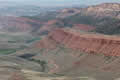
US191 heads directly to Grand Teton, but we turned off to spend the night near Lander. The road took us through South Pass, not famous for its scenery but very popular with wagon trains and later with the railroads. It is the lowest pass through the continental divide and it has gentle grades on both sides. It was part of both the Oregon Trail and the Mormon Trail.
The scenery picked up as we approached Lander with an overlook of Red Canyon. Our GPS found us a great shortcut to Sinks Canyon, 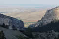 except that the far end of the short cut was closed, with bits missing. The GPS was so pleased with its route though that it kept finding new
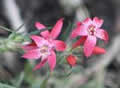 and ingenious ways to get us back to it. We eventually toured most of Lander before finding some signs and we followed those. Then we had great difficulty in finding the campground entrance. The park and the road and the river are squeezed into a small space with few entrances. We were lucky to find a site big enough for us.
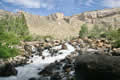
But it was worth it. The canyon is on the edge of the Wind River mountain range, famous for its dramatic scenery. It’s not an area we’ve  visited before as the best hikes, to areas like the Cirque of the Towers, take a few days, but Sinks Canyon has a few shorter ones, and we took off down a trail along the Popa Agie River, pronounced Popposha, I think. It was a nice walk, mostly though
 woods with canyon walls around us.
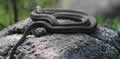
We found this snake perched on a rock and were pretty sure that it was a harmless garter snake. We arrived back at the campground in time for a ranger talk, appropriately enough on snakes, and we asked their opinion. Looking at the photo, their guess was a bull snake, also harmless, but I still think it was a garter.
 Early that morning Sandie had arrived in Calgary via Phoenix. Her flight came in during a storm and the plane was struck by lightning on its way down. The plane then had to sit on the runway until it was safe for the ground crew to go back to work.
  Karen collected her and they were home by 1.45am. The family went off later in the day to watch the Calgary Stampede parade, but Sandie chose to sleep instead.
 Saturday July 7th
We had enough time for some exploring in the morning. Sinks Canyon is so named because the river “sinks” into a cave and then reappears at the “rise” a quarter mile down the canyon. The big mysteries are why it takes two hours to cover that distance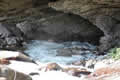 and why more water comes out than goes in. Some combination of underground rivers and networks of caves presumably. There’s also a great gathering of trout at the rise, but no mystery about that as there’s a feeding station on the overlook.
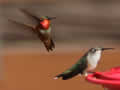
There were plenty of rufous hummingbirds around too, the same kind we have in Hope. As long as there was only one male around all was quiet, but the males (with the iridescent orange throat) are very territorial, with lots of squawking and divebombing of the competition.