2010/11 Australia trip - Bustard Bay, Eurimbula |
|||
Then we were off on a long mileage day. With this excursion into the backcountry, I had to admit that we were beginning the day about as far away from Melbourne as on the previous morning! Sandie found us a route through sugar farming country that brought us out onto the Bruce Highway, heading south again. We passed field after field of sugar cane, in various stages of growth, and sugar processing mills in all the towns. There didn’t seem to be any alternative crops: a monoculture like that seems destined for both financial and biological problems. We assumed that the demand for ethanol fuel was keeping the farms going.
Unlike up north where the little sugar trains seemed to have disappeared, replaced by trucks, here they were much in use, likely to pop out across the road when least expected. Further south the land looked rough and only fit for beef cattle and few of those. We passed through Rockhampton on the Capricorn Coast, and south of there we were no longer in the Tropics. Then we passed Gladstone, supposedly the southern limit of saltwater crocs, though we noted that the Boyne River south of there still had croc warnings posted.

I’d found a potential campsite on the coast at Eurimbula national park so we headed there only to find that the self registration system had been replaced by Queensland’s “smart” system whereby you have to call them and make a booking and pay by credit card. So we had to drive to the nearest town, Agnes Water, and find a pay phone and then spend twenty minutes on the phone. This guaranteed that it was dark by the time we’d driven back to the park
In this case, it was not only dark but the track into the park passed through some amazingly dense jungle: it was like driving down a tunnel, dodging the tree trunks on either side, hearing the vines slide over the roof, and bouncing over the tree roots in the track.
| Eurimbula (4.50) | 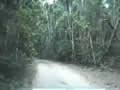 |
|---|
After a long drive through this jungle we came out onto the beach at Bustard Bay and grabbed the first campsite next to  the beach: some of the others were occupied, even though the booking person said we had the place to ourselves. Clearly, the others realized that no one was going to be driving into such a remote spot to collect a few dollars.
We could hear the surf pounding even though we hadn’t seen it yet. This was definitely a buggy spot, and we dug out the repellant for the first time on this trip
Supposedly this is one of the places where Captain Cook made a landing back in 1770. Back in 1970 one of the nearby towns renamed itself 1770 to celebrate this, and it’s probably been causing problems with computer programs ever since. How many towns can you think of that have just a number for a name?

 Wednesday October 27th
Sandie saw this weird pink car/boat while I was off on a walk. It motored across the bay with its propeller and then drove up onto the beach on its tyres. Our guess was that it was a tour boat from 1770. (It was, see http://www.1770larctours.com.au/)
Next